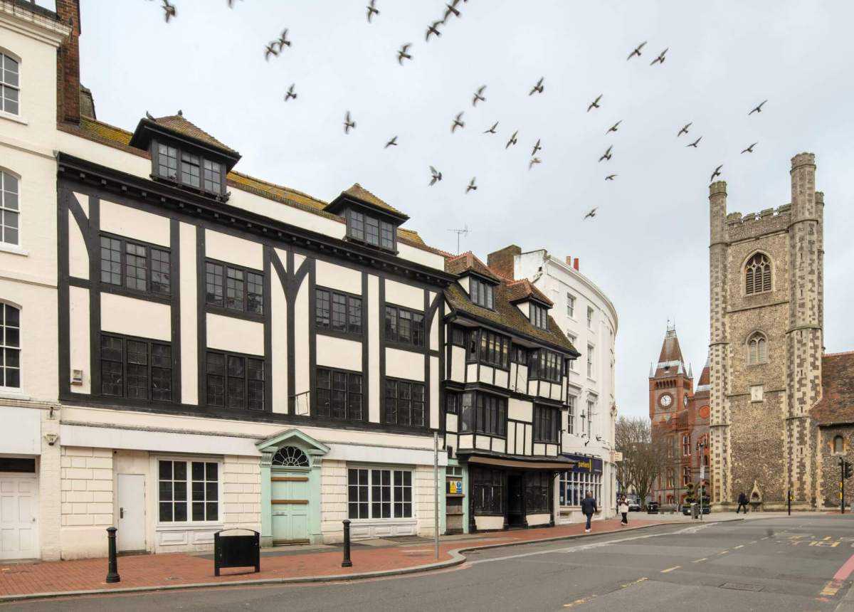
Blog

  • A Brief Introduction to Semi-Detached Housing

    A Brief Introduction to Semi-Detached Housing

    Semi-detached housing is England’s most prevalent type of housing, representing around one-third (more than 7 million) of all dwellings today, with 1 million in rural villages and hamlets.

    The inter-war period of the 1920s and 1930s was the boom era for this style of housing. The enormous building surge in the hinterland of the country’s towns and cities shaped what we often think of as archetypal suburbia.

    Weaver House and Number 2, Woolpit, Suffolk. A rare late 15th-century example of 2 houses built as one. © Mr Roger Eburne. Source: Historic England Archive. View image IOE01/07480/10. View List entry 1181659.

    However, the origins of the semi-detached house go back centuries. Here, we look at the story of its development from rural origins to the 21st century.

    Early rural development: The 17th and 18th centuries

    Most semi-detached houses (earlier known as double cottages or double houses) are constructed as a symmetrical pair with a common wall between them. Each house mirrors the other in plan, with space down the side to access the rear from the street.

    A drawing of a floor plan of 2 semi-detached cottages showing the kitchens, sitting rooms, porches and pantries.
    A group floor plan of a double cottage, Shooter’s Hill, originally in Kent. One of a pair of 6, built in 1827 by the Labourer’s Friend Society. Source: Creative Commons.

    Accommodating residents on either side, semi-detached houses entailed lower construction costs and could be built more quickly.

    There is the occasional early reference to a handful of such properties in rural areas in England in the 17th century.

    However, this type of dwelling was also built in small groups in rural England in the 1800s by landowners who viewed their workers’ old cottages as an eyesore and ordered them demolished and rebuilt.

    A photograph of the side of a thatched cottage surrounded by bushes and a fence.
    An example of an 18th-century double cottage in Ashbury, Idstone, Oxfordshire. © Mr John Rendle. Source: Historic England Archive. View image IOE01/10816/33.

    Model villages: Late 18th century

    One of the best-known examples was created by the Earl of Dorchester, Joseph Damer (1718 to 1798), who remodelled Milton Abbey in Dorset into a great house.

    He pulled down the original medieval village before housing the estate’s agricultural workers in the newly built model village of Milton Abbas, with its 40 semi-detached thatched houses.

    An aerial photograph of rows of semi-detached thatched cottages on a road surrounded by woodland.
    The village of Milton Abbas in Dorset, built in 1771, designed by architect William Chambers and landscaped by Capability Brown. Source: Creative Commons. View List entry 1118595.

    The cottages were each deliberately designed to look like one house with a single entrance, but up to 4 families shared each dwelling.

    This single entrance design concept endured in certain locations across England for the next couple of hundred years.

    Semi-detached housing in London: 18th and 19th centuries

    The Industrial Revolution transformed Britain. The population increased from 1 million in 1800 to nearly 6 million over the next 100 years.

    By the 1880s, nearly 70% of the population lived in urban areas. This was the result of rural workers moving to towns and cities in search of factory jobs and other work. Overcrowding and poverty were rife.

    An old map of the city of London showing the River Thames flowing through the centre.
    John Rocque (1704 to 1762), a French-born cartographer, created this 24-sheet pre-Industrial Revolution map of London in 1746. The capital then was relatively small. As the decades progressed, London spread outwards in every direction. Source: Public Domain.

    City centres in Britain had traditionally housed both the prosperous and the working classes, but the Industrial Revolution hugely expanded a middle class with disposable income.

    These city traders, bankers, shipping magnates, merchants and industrialists now wanted to move out of city centres and flaunt their wealth in fashionable new suburbs, setting in motion the future development of semi-detached housing in towns and cities, with the capital leading the way.

    A photograph of a crescent of 5 blocks of grand, 4-storey semi-detached houses overlooking a road and a large green space with trees.
    The Paragon, Blackheath, London, was built over 12 years from 1794. © Historic England Archive. View image DP186837. View List entry 1211997.

    The Paragon in Blackheath, London, was one such desirable development, constructed speculatively for the newly wealthy middle classes.

    It featured 7 enormous houses in a crescent, each linked by a single-storey colonnade. Although the houses appeared detached, they were, in fact, semi-detached, with 2 dwellings per house. The entrances were within the colonnades.

    London’s first planned suburban estates: Early 19th century

    The design of the Eyre Estate originated at the end of the 18th century on 500 acres of open fields bought earlier in the century by wine merchant Henry Samuel Eyre.

    A photograph of the exterior of a 2-storey semi-detached stuccoed Italianate house surrounded by a metal fence and bushes.
    A semi-detached stuccoed Italianate villa, Eyre Estate, St John’s Wood, London. Source: Creative Commons.

    The estate, constructed in the early 19th century, is an early example of a large, planned London suburb, although almost none of the plans were realised as initially conceived.

    Architect John Shaw (1776 to 1832) included a proposal for pairs of semi-detached dwellings, a novelty at the time, including Italianate and Gothic-style villas.

    A photograph of the exterior of a large, semi-detached Italianate villa with numerous tall chimney stacks.
    2 to 4 Park Village East, St John’s Wood, London. This is a semi-detached Italianate villa in a street of 12. Park Village East and Park Village West were laid out in 1825 by John Nash, one of the foremost British architects of the early Georgian and Regency eras (1714 to 1830). Source: Historic England. View image DP186637. View List entry 1322056.

    In the 1820s, architect John Nash (1752 to 1835) constructed a small group of houses, Park Village East and Park Village West, near Regent’s Park in London.

    Most were designed as semi-detached dwellings, but appeared like a single house. These were picturesque, stuccoed, mostly Italianate villas for the people who wanted social recognition, privacy, and the leafy illusion of the countryside.

    Both the Park East and Park West Villages and the Eyre Estate heralded the increasing acceptance of semi-detached dwellings by the middle class, which percolated through society in the following decades.

    Semi-detached housing in the early to mid-Victorian era

    The Victorian era (1837 to 1901) saw a huge growth of the middle classes.

    A photograph of the exterior of 2 3-storey, semi-detached neo-classical villas with front gardens beside a road.
    A mid-19th-century pair of neo-classical, semi-detached stuccoed villas in Bedford, Bedfordshire. Source: Historic England Archive, 1OE01/00515/27. View List entry 1129015.

    The growth of the middle classes was paralleled by a matching boom in house building, including many terraced housing estates for the growing industrial workforce. Renting for all levels of society continued to be the norm.

    Affluent suburbs, which form settlements with a clear relationship with a nearby town or city but with their own distinctive character, started to develop for wealthier families who wanted to move away from urban life into the countryside.

    As a result, semi-detached housing became a desired housing type.

    Architectural pattern books

    Much of the new housing across the country was built without architects, using architectural pattern books instead.

    A scan of 2 pages of a historic book showing architectural designs for house building on the left page, with text on the right page.
    Sample pages from William Halfpenny’s mid-18th-century pattern book, ‘The Modern Builder’s Assistant’, or ‘A Concise Epitome of the Whole System of Architecture’. Source: Public Domain.

    These building ‘bibles’ were first published in the 18th century and surged in the following century. Such books allowed for the sharing of designs and sources of inspiration for owners and builders.

    There was limited planning control at this time. However, from the mid-19th century, following fatal cholera outbreaks, various public health and other acts were passed which allowed for building byelaws to be adopted requiring the proper provision of space, light and sanitation for new houses.

    A photograph of the exterior of a row of grand semi-detached linked houses with sash windows beside a road.
    A group of semi-detached linked villas on Lloyd Street, Clerkenwell, London, built in 1832, shows elements of Georgian style and its gradual development, here using large bands of decorative stucco. © Historic England Archive. View image DP041994. View List entry 1207955.

    This represented an enormous advance in living conditions for the working and lower-middle classes.

    Architectural style in the mid to late Victorian era

    By the mid-19th century, the Victorian imagination was in thrall to medieval Gothic ecclesiastical architecture and romantic literature, such as Walter Scott’s novels.

    A photograph of the exterior of 2 Gothic Revival-style semi-detached houses surrounded by a gravel path, grass and trees.
    These Victorian semi-detached houses in Canterbury, Kent, demonstrate typical Gothic Revival features such as high pointed gables with deep projecting eaves, mullioned windows, and rusticated stonework. Source: Creative Commons. View List entry 1241023.

    Gothic Revival architecture became fashionable, embodied by the rebuilt Houses of Parliament, designed by British architect Charles Barry, and by new rail stations such as St Pancras in London.

    The Gothic Revival style was soon embraced by Victorian speculative builders of domestic housing who, across the era, also freely borrowed from an eclectic range of other architectural styles, including Italianate, Tudor and vernacular.

    A photograph of the exterior of a highly decorative bay window with stone capitals adorning the edges of the windows.
    An example of capitals carved with acanthus leaves as bay window decoration in a late Victorian house in Camberwell, London. Source: Nicky Hughes.

    From around the middle of the 19th century, the middle classes who could not afford a detached house but wanted to differentiate themselves from what they considered socially inferior urban terraces, embraced the semi-detached in all its styles, if it was flamboyant and in an acceptable location.

    Alongside this, the expansion of public transport and the building of new roads meant more people could live further away from home and commute to work, resulting in a further development of the suburbs and a proliferation of semi-detached housing.

    Model industrial villages

    While over half the population in the latter 19th century were still living in the cramped slum terraces and tenements of towns and cities, there were also philanthropic industrialists keen to improve their workers’ lives.

    A black and white photograph of 2 mock Tudor style semi-detached houses with large chimneys beside a road.
    A pair of semi-detached houses photographed in 1896, built in the picturesque Tudor style in the model village of Port Sunlight, Merseyside, created by William Hesketh Lever, later Lord Leverhulme (1851 to 1925), to house workers from his soap factory, Lever Brothers. Source: Historic England Archive. View image BL13547/027. View List entry 1116162.

    Many created model villages, offering a healthy, pleasant environment to increase productivity and cement loyalty to the firm.

    The drawings of housing plans for a new estate, showing a variety of styles of houses and different floor plans.
    A plan for housing in Bournville model village, Birmingham, with designs for semi-detached homes at the top. Source: Creative Commons.

    There are several outstanding examples of such paternalism, including the Bournville model village, built mainly in Arts and Crafts style. This was overseen from 1900 by a trust established by the Quaker George Cadbury, the chocolate manufacturer and social reformer, although occupation wasn’t limited to the factory workers.

    Semi-detached housing in the early 20th century

    The Garden City Movement

    Model villages and other housing reform initiatives, as well as self-help schemes like co-partnership, profoundly influenced the Garden City Movement, founded by Ebenezer Howard (1850 to 1928) as a reaction against the ongoing social problems of towns and cities.

    A photograph of a road featuring semi-detached houses with front gardens with large trees.
    Semi-detached housing in Handside Lane, Welwyn Garden City, Hertfordshire, the city’s oldest area. This was one of many streets of semi-detached housing where styles vary from large, high neo-Georgian to cottages. Source: Jerry Young.

    Garden Cities, such as Letchworth (begun in 1903) and Welwyn Garden City (begun in 1919), both in Hertfordshire, were intended to reverse the countryside’s depopulation. They offered self-contained suburbs in a countryside setting that included jobs in industry and agriculture and new homes, many of which were semi-detached.

    The Garden City Movement and its adjunct, the garden suburb, which got underway at Hampstead in 1907, strongly influenced the design and planning of suburbs.

    The Inter-War period (1919 to 1939): The semi-detached housing boom years

    The greatest concentrations of semi-detached housing in England were built in the suburbs between the First and Second World Wars. Today, this house style is synonymous with suburbia for most people.

    An aerial photograph of rows of semi-detached houses with large gardens in a suburb of a city.
    An estate of 1930s semi-detached housing in Tolworth, Kingston-upon-Thames, Greater London. © Light /Alan Spencer / Alamy Stock Photo.

    The years following the First World War (1914 to 1919) were marked by an enormous shortage, estimated as being around 600,000 homes in 1918.

    The housing crisis, as well as demographic and societal changes, spawned numerous parliamentary acts, recommendations and reports. The Tudor Walters Report (1918) was highly influential in terms of recommendations for suburban house building, while the government’s Housing Manual (1919) provided house plans, two-thirds of which were for semi-detached housing.

    A photograph of the exterior of 2 mock Tudor-style semi-detached houses with timber-frames and small front gardens.
    A 1930s Tudorbethan semi-detached house in Surrey. During the inter-war years, tens of thousands of builders constructed around 3 million semi-detached houses in Britain. © Charlie Stroke / Alamy Stock Photo.

    Private developers built speculative estates of predominantly semi-detached homes in the suburbs of virtually every English town and city, in styles ranging from the popular and aspirational ‘Tudorbethan’, to neo-Georgian, Art Deco, flat-roofed Modern and neo-vernacular.

    New state-aided council housing boomed because, although previously permitted by government legislation under the Housing, Town Planning Act 1919, it became a duty for local authorities.

    A photograph of the exterior of 2 semi-detached houses with a large green space and tree in front.
    Semi-detached council housing on the Sunray Estate, Dulwich, London, built between 1921 and 1924. © Historic England Archive. View image DP186782.

    The middle classes, swollen in number by white-collar workers, and with cheap loans offered by the growing number of building societies, were now often able to buy their own semi-detached homes and commute from the suburbs to their urban workplaces.

    For most people, including both the middle class and increasingly the working class, the semi-detached house with its large garden, privet hedges and leafiness giving a feeling of countryside, was now the most popular and aspirational residence.

    Housing from the 1950s to the early 21st century

    Britain suffered an acute housing shortage following the Second World War (1939 to 1945). Half a million homes were destroyed by aerial bombardment, and hundreds of thousands of other homes were damaged.

    A photograph of a row of post-war semi-detached houses on a road with front gardens and large bushes.
    Post-war semi-detached housing in Milton Keynes, Buckinghamshire. © Historic England Archive. View image DP235482.

    The provision of new council housing was a top priority in addressing the crisis. 2.5 million houses and flats were built across the country in the 10 years from 1946, often planned as neighbourhoods embracing new ideas of how people should live. Three-quarters were built by local authorities.

    Over 150,000 prefabricated homes were constructed, as well as over 22 government-funded New Towns, including Harlow and Basildon. Stevenage was the first to be built from 1946, and Milton Keynes was the last from 1967, giving homes to around 2 million people.

    Situated beyond the Green Belt, New Towns offered employment opportunities and brand-new, well-built homes, many of which were semi-detached.

    A black and white photograph of newly built semi-detached houses with 'sold' signs by the front doors.
    Newly built semi-detached housing on Sycamore Close, Bradford, West Yorkshire, in 1977. Source: Historic England Archive. View image P/H00683/003.

    Across the country, semi-detached housing remained a dominant type and the most common dwelling until the 1960s, when it started to decline as a primary building style in favour of more mixed housing solutions.

    Suburban developments in the modern era, for example, now often centre on small estates, including on the fringes of towns and villages, with a mix of semi-detached and detached housing and short terraces.

    Cities feature modern high-rise private apartment blocks, while local authorities and housing associations are building large numbers of social housing flats, maisonettes and houses.

    A photograph of the exterior of the back of a modern semi-detached house with large. floor to ceiling windows on the ground floor, with a glass balony on the first floor, and a metal panelled  roof.
    The rear view of one of 4 pairs of semi-detached houses on the Stirling Prize-winning Accordia Estate, Cambridge, in 2006. Source: Alison Brooks Architects.

    Yet, despite this, as government statistics show, semi-detached housing is still the most prevalent type of housing today, representing around one-third of all homes in England.

    Today, architects continue to experiment with a form that has maintained its popularity and usefulness in suburban development across the country.

    Written by Nicky Hughes

    Hidden local histories are all around us. Find a place near you on the Local Heritage Hub.


    Further reading

  • Uncovering Local History Hidden on our Streets – The Historic England Blog

    Uncovering Local History Hidden on our Streets – The Historic England Blog

    Can you define England without mentioning post boxes or telephone boxes?

    We are surrounded by historic designs and constructions that were initially invented for everyday purposes, such as to inform us where we were going, communicate with one another, or even drink water.

    A crinkle crankle wall on Scudamore Place, Ditchingham, Norfolk. © Historic England Archive. View image DP162740.

    Yet, they were all groundbreaking innovations at the time and helped to define England as it moved from the post-medieval period (AD 1540 to 1901), through the Industrial Revolution and into the 20th century.

    While many look similar, the details and tiny variations of these objects can help tell us what was happening in your local community at a certain period in our history.

    Here is an introduction to some of the most common ‘street furniture’ found across the country.

    17th century onwards: Milestones, mileposts and signposts

    Road signs might seem ‘everyday’ now, but the idea is only a few hundred years old. Before that, many distances were only marked on stones (hence the name ‘milestone’).

    A photograph of a small milestone surrounded by grass with the wording 'V Miles to Glocester' inscribed on it.
    This milestone sits alongside the B4073 near Painswick, Gloucestershire. © Historic England Archive. DP438674. View List entry 1447094.

    Later examples were also made from cast iron, as manufacturing technology advanced.

    As more roads were built, knowing where people were going became increasingly important. Some historic signposts are known as ‘finger posts’ because they point in different directions.

    A photograph of a metal fingerpost pointing in 3 different directions on top of a stone plinth.
    This fingerpost sits at the junction of B4077 and Church Lane, Toddington, Gloucestershire. © Historic England Archive. View image DP464625. View List entry 1489707.

    The number of signposts in England increased with the rise in road traffic after the 1860s and changed character with the introduction of motor traffic at the start of the 20th century.

    Increasing speeds on the roads made easy legibility even more important.

    A photograph of a road sign featuring 6 different locations with a small lamp on the top of it. A cathedral can be seen in the background.
    The ‘Pillar of Salt’ road sign in Bury St Edmunds, Suffolk, was built in 1935. © Historic England Archive. View image DP070101. View List entry 1376516.

    However, it wasn’t until the 1930 Road Traffic Act that the colour and appearance of signs and signposts were standardised across the country.

    While we don’t know precisely how many milestones, mileposts, and historic signposts there are across England, we do know that over 3,000 milestones, mileposts, fingerposts, and signposts are included on the National Heritage List for England.

    From 1852: Fountains, troughs and water pumps

    Public drinking fountains and water pumps can be found in many urban and rural places, especially within public parks.

    A black and white photograph on a postcard showing children leaning over the edge of a large stone water fountain in a park.
    This postcard shows the fountain in Corporation Park, Blackburn, Lancashire, and is part of the Nigel Temple Collection. © Historic England Archive. View image PC09417. View List entry 1001344.

    They were initially intended as a health intervention in the Victorian era, as introducing safe drinking water into communities helped stop the spread of deadly illnesses like cholera.

    Today, over 550 are included on the National Heritage List for England.

    The first drinking fountains were installed in Liverpool by Charles Pierre Melly, who had seen examples during a visit to Geneva, Switzerland, in 1852.

    A photograph of a postcard of people standing on the steps leading to a large, ornate drinking fountain in the centre of a park.
    The Baroness Burdett Coutts Drinking Fountain in Bethnal Green, Tower Hamlets, Greater London, shown in a postcard from the Nigel Temple Collection. This image was taken between 1900 and 1930. © Historic England Archive. View image PC06763. View List entry 1235552.

    Through the years, many public fountains have also been made into monuments, donated or installed to mark a significant moment or person in England’s history.

    One example is the Baroness Burness Coutts Drinking Fountain in Victoria Park, Tower Hamlets, Greater London. It is one of only a handful of drinking fountains that are Grade II* listed.

    A photograph of a stone water fountain and water trough filled with flowers beside a road.
    Hyde Vale drinking fountain and cattle trough, Hyde Vale, Blackheath, Greenwich, Greater London. © Historic England Archive. View image DP371258. View List entry 1031858.

    It’s not just people who were the intended recipients of these free watering holes. The Metropolitan Free Drinking Fountain Association, formed in 1859, changed its name to include cattle troughs in 1867. These special troughs provided drinking water for cattle and other animals entering market towns.

    With clean, safe water now freely available, many drinking fountains and troughs have found new uses, including as planters.

    From 1853: Post boxes

    The first Royal Mail post boxes were installed in England in 1853. Early post (or letter) boxes were red and hexagonal in shape, making them easy to spot, but also heavy and expensive to produce.

    A photograph of a close up of the top of a post box featuring the wording 'Post Office'. A telephone box can be seen in the background.
    A pillar box, or post box, and a telephone box in Warwick. © Historic England Archive. PLB/N110029.

    In 1859, a cylindrical design that was cheaper and easier to make was introduced around the country. You might also have seen post boxes fixed to walls, which began to be used in 1857.

    By the end of the 19th century, there were over 33,500 post boxes in the United Kingdom. There are currently over 85,000!

    A photograph of a post box installed in a wall.
    This post box in Talskiddy, Cornwall, dates from 1881. We can tell from the cypher that it was made before 1901. © Historic England Archive. View image AA009382.

    Post boxes also include another clue to dating them. The Royal cypher (a type of symbol) is made up of the first initial of the king or queen’s first name, together with the letter R, which either stands for Regina (queen) or Rex (king) in Latin.

    A photograph of a close-up of an insignia on a post box. The lettering features 'GR VI'.
    This is a close-up of the ‘GR VI’ insignia on a pillar box, which dates the box from 1936 to 1952. © Historic England Archive. View image DP075238.

    Most recent cyphers also include a Roman numeral, used when the king or queen wasn’t the first one with that name, all except for George V, who just used ‘GR’.

    A diagram showing the 8 different royal cyphers of monarchs.
    Use this cypher chart to help you discover how old your local post box is.

    From 1921: Telephone boxes

    Although many telephone boxes now have other uses (including libraries, first aid stations, and even coffee shops), they are still an important part of many high streets across the country, and can be a focal point in rural villages and towns.

    In fact, in 2015, they were named as the nation’s favourite British design.

    A photograph of a telephone box and a small post box beside a wall on the corner of a small street. A historic house can be seen in the background.
    K6 telephone box number 038673289, Stanton, Gloucestershire. This box is now reused as an information centre. © Historic England Archive. View image DP139038.

    One of the earliest examples, known as the K1, was designed in 1921 and made from concrete with a red wooden door.

    Since then, there have been many developments in the design, although the red K2 and K6, designed by architect Sir Giles Gilbert Scott, are the most well-known.

    A photograph of 4 telephone boxes lined up.
    A row of K6 telephone boxes in Bournemouth, Dorset. © Historic England Archive. View image DP132100.

    Not if you happen to live in Hull, though. You might not know that not all telephone boxes are red. In 2023, 2 rare K8 telephone boxes were listed in Hull, East Yorkshire.

    Hull is the only place in England where the local council ran the public telephone network, having originally been granted a licence to operate from 1902. To demonstrate the network’s independence, these telephone boxes are painted cream.

    And, of course, some very famous telephone boxes are a rather fetching shade of Blue! ‘Doctor Who’ first came to our screens in 1963, with the Doctor’s Tardis appearing as a police telephone box in the first ever episode.

    Its designer, Gilbert Mackenzie Trench, was surveyor and architect to the Metropolitan Police from 1920 to 1945. These particular incarnations of the Tardis are now a rare sight in England, but examples can still be found in Sandside, North Yorkshire and Newton Linford, Leicestershire.

    2025 and beyond: Your historic local heritage

    Local discoveries are all around us. If you are inspired to discover more in your local area, find a place near you on the Local Heritage Hub.


    Further reading

  • The History of the Railway in England

    The History of the Railway in England

    The world’s first standard gauge, steam-hauled public railway, the Stockton and Darlington, opened on 27 September 1825, connecting places, people, and communities. It went on to transform the world.

    A railway revolution swept Britain in the 19th century, changing the country forever. A predominantly agricultural society had metamorphosed into an urbanised industrial superpower.

    ‘The Opening of the Stockton and Darlington Railway, 1825’, painted by Terence Tenison Cuneo, 1949. © Reproduced with kind permission of the Cuneo estate / Bridgeman Images. Image credit: National Railway Museum / Science and Society Picture Library.

    2025 marks the 200th anniversary of the birth of the modern railway. Railway 200 is a year-long, nationwide campaign to celebrate 200 years of the modern railway.

    England’s spectacular historic environment includes numerous sites and places related to the story of rail.

    The Railway 200 website includes a timeline highlighting some of the significant moments that defined the railway. Here, we will explore some of the fascinating sites which illustrate that timeline.

    When was the first steam train invented?

    While the Stockton and Darlington is generally accepted as the world’s first public railway to use steam locomotives, there were many earlier railways, some also public, some using steam power. Guided systems of transport, horse-drawn or man-worked, had developed across the mining areas of North East England throughout the 18th century.

    The magnificent Grade I listed Causey Arch still stands today and is a monument to those pioneering wagonways. It was built in 1727 and is considered to be the earliest surviving railway bridge in the world.

    A black and white photograph of a stone wagonway bridge surrounded by trees on the banks nearby.
    The earliest surviving railway bridge in the world, the Causey Arch, Causey Road, Stanley, County Durham. © Crown Copyright. Historic England Archive. View image AA93/01333. View List entry 1240816.

    These days, it carries a footpath alongside the Tanfield Railway, a heritage line. The Tanfield Railway itself runs on the formation of an early wagonway and, as such, has a credible claim to being the world’s oldest operating railway.

    These wagonways were all horse-powered, however. Early experiments with steam took place in the early 19th century. Cornish engineer Richard Trevithick designed the Pen-y-Darren locomotive in 1804, which was used to haul coal on the Merthyr tramroad (now a scheduled monument) in Wales.

    Trevithick then designed a locomotive to haul passengers in 1808. The catch-me-who-can ran on a circular track in London’s Euston Square to attract investors. While he failed to win investors, Euston Square later became the terminus of London’s first inter-city railway, the London and Birmingham, in 1838.

    Today, that innovation continues, with Euston Station being rebuilt as the terminus of HS2. The West Midlands end of HS2 will also have a strong heritage connection, incorporating the Grade I listed 1838 Birmingham terminus building.

    When was the first passenger train invented?

    On 27 September 1825, the 26-mile Stockton and Darlington Railway opened with a special train of over 30 coal wagons and one passenger coach (‘Experiment’), hauled by a steam locomotive. Starting near Shildon, north west of Darlington, it made several stops before finishing at Stockton. This train carried over 500 passengers.

    However, early regular passenger services on the line were single coaches hauled by horses. The limited number of available locomotives were reserved for heavy coal trains. Regular steam-hauled passenger trains on the Stockton and Darlington started in 1833, after such services had been running on the Liverpool and Manchester Railway for 3 years.

    Much of the 1825 main line remains part of the national rail network, including the Skerne Bridge, built in early 1825 and subsequently strengthened.

    A photograph of a stone railway bridge with a small train travelling over the top of it.
    Skerne Railway Bridge, John Street, Darlington, County Durham. © Historic England Archive. View image DP175630. View List entry 1475481.

    Darlington North Road Station was built a few years later and is situated just to the west of the bridge. The station has recently been restored as part of Darlington’s Railway Heritage Quarter and Hopetown, a new railway heritage attraction.

    George Stephenson was the engineer for the Stockton and Darlington Railway and, with his son, Robert, built the railway’s first steam engine, Locomotion No 1, which still survives and can be seen at Locomotion in Shildon.

    A few years later, Robert designed and built the Rocket locomotive (also known as ‘Stephenson’s Rocket’) in their Newcastle works, which still exists today and is the world’s first purpose-built locomotive factory.

    A black and white aerial photograph of a city with a river flowing through the centre and multiple railway tracks and buildings.
    The Central Railway Station and the city, Newcastle upon Tyne, Tyne and Wear. © Historic England Archive. View image EPW060867. View List entry 1391237.

    The Rocket was built for the Rainhill trials, a competition amongst engineers to find suitable machines to operate the Liverpool-Manchester Railway, the world’s first inter-city line, in 1830 (although neither Liverpool or Manchester were considered cities at this point).

    Happily, the Rocket also still exists and can be seen in the National Railway Museum in York.

    A black and white photograph of a statue of Robert Stephenson on a plinth beside a small classical-style building.
    The Robert Stephenson statue in Euston Square, Camden, Greater London, photographed between 1870 and 1900. Source: Historic England Archive. View image CC97/00265. View List entry 1342041.

    In 1825, the concept of the railway station had yet to evolve and none had been built for the opening of the line.

    The Grade II* listed Heighington and Aycliffe Station, built in 1826 as a tavern to supervise a coal depot, was fulfilling the functions of a railway station by 1828 and lays claim to being the earliest railway station in the world.

    A photograph of a small, single-storey stone railway station beside a railway track.
    The Heighington and Aycliffe Railway Station in Newton Aycliffe, County Durham. © Niall Hammond / Friends of the Stockton and Darlington Railway. View List entry 1322808.

    However, it did not take long for stations to develop a form we still recognise today, based on a pavilion with canopies and platforms. Perhaps the earliest surviving ‘modern’ station is the Grade II listed Micheldever, on the London and Southampton Railway of 1840.

    The development of railway towns

    As railways developed, entire railway towns emerged to house the staff required to build and operate the railways.

    Swindon in Wiltshire is a good example of an early railway town. The market town already existed, but Isambard Kingdom Brunel built a ‘New Swindon’ to house the staff of the Great Western Railway alongside it.

    His Grade II listed railway workers’ cottages are part of one of our Heritage Action Zones, designed to capitalise on Swindon’s railway heritage to foster economic, social and cultural enterprise.

    A photograph of a terrace of small, stone cottages.
    Workers’ cottages on Bristol Street, Railway Village, Swindon, Wiltshire. © Historic England Archive. View image DP263277. View List entry 1023465.

    Alongside Stephenson, Brunel figures strongly in the history of early inter-city railways. Not all his ideas were a success, however. While his line between London, Bristol, and slightly later, Exeter, were engineered with minimal gradients that permit very high speed, he had a different plan for the undulating terrain between Exeter and Plymouth.

    It was envisaged that trains would run on a vacuum system. A stationary engine would pressurise a tube, and a vehicle would carry a piston travelling in the tube. You can see a section of the original tube at Didcot Railway Centre.

    Problems with sealing the slot to enable the piston to enter the tube led to the project’s abandonment, but a Grade I listed engine house at Starcross survives as a monument to the failure. The building is currently on our Heritage at Risk Register, and we are advising on solutions.

    Another Heritage Action Zone in Lancaster also has a railway connection. Numbers 4 and 5 Stonewell, recently restored using our grant funding, were the home of Thomas Edmundson, inventor of the pre-printed railway ticket. Tickets were numbered and validated by a date-stamping process, allowing simple accounting.

    A photograph of a row of 3-storey traditional stone buildings with a post office and a delicatessen on the ground floors.
    4 and 5 Stonewell, Lancaster, Lancashire. © Historic England Archive. View image DP439252.

    All change please

    The railways brought about monumental changes to society, expanding the possibilities for travel, work and trade. Before the arrival of the railways, time was typically determined in each town by a local sundial, resulting in variations in local time.

    Local time in Bristol, for example, was 11 minutes behind local time in London. The Great Western Railway first applied a standardised time arrangement, but railway time quickly became adopted as the default. In Bristol, the clock on the Grade I listed Corn Exchange still has 2 minute hands: one for railway time, and one for Bristol time.

    A photograph of a large, classical-style building with a clock at the centre.
    The clock on The Exchange, Corn Street, Bristol. Contributed to the Missing Pieces Project by Charles Watson. View List entry 1298770.

    The railway was a driving force behind societal change, and this is reflected in J.M.W. Turner’s famous painting ‘Rain, Steam and Speed’, which depicts a Great Western Railway (GWR) train rushing across Maidenhead Bridge, now a Grade I listed structure.

    However, many view the painting as an allegory for societal change, as the train hurtles towards an industrial future.

    The boom of the seaside holiday

    Though travel was generally divided into 3 classes, the railways were a great leveller in terms of mobility. Holidays by rail experienced significant growth throughout the 19th century, with entire resorts being created in seaside areas.

    Scarborough in North Yorkshire, for example, expanded massively after the arrival of a railway from York in 1845, and its Grade II listed station remains today.

    A black and white photograph of the exterior of a railway station building with an elaborate baroque clock tower at the centre.
    Scarborough Railway Station, Westborough, Scarborough, North Yorkshire, photographed in 1983. © Crown Copyright. Historic England Archive. View image BB99/11743. View List entry 1243452.

    Bournemouth in Dorset did not exist before the railways, although its grand, continental-style station dates from 1885, 50 years after the town’s first villas.

    Weston-super-Mare in Somerset was also a product of the railways. The size of the staircases at its Grade II listed station shows the vast size of the crowds that would once rush through, although the adjacent excursion platforms are long gone.

    A black and white aerial photograph of a seaside town with a large pier in the background.
    A view over Weston-super-Mare in Somerset, which was a popular seaside resort thanks to the development of the railways. © Historic England Archive. View image EPW001037.

    Green signals

    One interesting survivor in Weston-super-Mare is what is thought to be the country’s earliest surviving signal box. A modest little building, now disused and slightly forlorn in the corner of a contractor’s compound, it was built in 1866 and predates the station by 10 years or so.

    A photograph of a small signal box building with boarded-up windows. A railway platform is in the background.
    Signal box, Weston-super-Mare Station, Weston-super-Mare, North Somerset. © Historic England Archive. View image DP218287. View List entry 1129748.

    Signalling improvements nationwide brought considerable safety benefits, and today, train travel remains one of the safest forms of travel.

    Very early railways were controlled by ‘railway policemen’ using flags, but mechanical signal boxes needed to be developed to protect the safety of trains. The invention of the railway telegraph allowed messages to be sent ahead of trains.

    In 1845, a murder suspect boarded a train at West Drayton, but the electric telegraph enabled him to be apprehended on arrival at Paddington Station. The original Paddington Station was located slightly west of the magnificent present-day station, now a Grade I listed building, which opened around 10 years later in 1854.

    A photograph of the interior of a large railway building with a curved ceiling and a large, ornate clock on the wall beside the platform.
    London Paddington Station, London Street, Westminster, London. Contributed to the Missing Pieces Project by F Jones. View List entry 1066881.

    Anything off the trolley?

    As train travel became the norm in the 19th century, passengers began to demand both comfort and speed. GWR pioneered the railway buffet, opening the first-ever railway refreshment room at Swindon station.

    All trains stopped here for 10 minutes, but this prevented the speeding up of trains. GWR was sued by the buffet landlord when Exeter services began running non-stop in 1845.

    The Grade II listed station buildings at Swindon’s London-bound platform, which contained a buffet, still survive.

    A painting of the interior of an ornate room at a railway station filled with people in Victorian dress sitting and talking, or walking, surrounded by luggage.
    ‘The Buffet, Swindon Station’ by George Elgar Hicks, painted in 1863. Source: Public domain.

    Electric trains: Into the 20th century

    Just as steam had supplanted the horse at the start of the 19th century, in the late Victorian period, a new form of traction began to emerge – electric. The first electric railway in the country was a short, narrow-gauge passenger line along Brighton Beach, and fantastically, it still runs today.

    Passengers can travel on the Volks Railway in the summer months. Although none of its original buildings now exist, the Grade II* listed cast-iron arcade at Madeira Terrace still forms the backdrop to the railway and is currently being restored using our grant aid.

    A photograph of a close-up of a dilapidated cast-iron arcade.
    Madeira Terrace, Madeira Drive, Brighton, Brighton and Hove, East Sussex. © Historic England Archive. View image DP487742. View List entry 1381696.

    Early electric trains also offered a solution in central London. While steam engines could be used on underground railways constructed just beneath the street using cut-and-cover tunnels with frequent vents, it would be impossible to operate steam in deep-level tunnels.

    The City and South London railway was the world’s first electric metro and still runs today as London Underground’s Northern Line. Grade II Listed Kennington Station is an example of one of the earliest deep-level tube stations.

    The rapid success of the underground led to the development of electric solutions to similar problems, as seen with the use of steam trains elsewhere. The railway tunnel under the Mersey in Liverpool opened in 1886 (one of its pumping stations is Grade II listed), but steep gradients and frequent services meant the tunnel was often filled with smoke.

    The line was electrified and transformed: whitewashed, electrically lit stations presented a modern and futuristic image to the Edwardian passenger.

    Travelling into the modern age

    The public’s perception of electrification provided the railways with an opportunity to create a new, modern image, one far removed from the smoking and clanking world of steam.

    The Southern Railway adopted electrification following successful experiments by its predecessors, the London and South Western Railway and the London, Brighton and South Coast Railway. The Southern electrified at pace, with striking new stations in an Art Deco style. Many of these remain today, but the crown jewel is probably Grade II listed Surbiton.

    A photograph of the exterior of a small, Art Deco-style train station.
    Surbiton Station, Victoria Road, Surbiton, Kingston upon Thames, Greater London. Contributed to the Missing Pieces Project by Brian Mawdsley. View List entry 1185071.

    Surbiton was designed by the Southern Railway’s in-house architect team under James Robb Scott. Robb-Scott is something of an enigma. He could turn his hand to a wide range of styles, from the art deco of Surbiton to the Edwardian Baroque of Waterloo’s Victory Arch via the Neo-Georgian Ramsgate.

    However, despite his work in transforming the image of travel in the early 20th century, he remains relatively little-known as an architect.

    Protecting our rail heritage

    Electrification remains one of the most efficient forms of propulsion on today’s rail network. We work alongside Network Rail to ensure that Victorian infrastructure is sensitively adapted as more lines are electrified, helping to ensure this can still perform the job it was designed for all those years ago.

    The railway is not a museum; its primary purpose remains to carry passengers and freight. However, 200 years of public railways have left a remarkable architectural legacy, one that continues to evolve and develop.

    In a few years’ time, in an almost full circle moment, HS2 trains will leave from Euston, where Trevithick demonstrated his steam locomotive.

    Written by Simon Hickman

    Hidden local histories are all around us. Find a place near you on the Local Heritage Hub.


    Further reading

  • Exploring the Myths of the Wars of the Roses Battlefields

    Exploring the Myths of the Wars of the Roses Battlefields

    2025 sees the 30th anniversary of the establishment of Historic England’s Register of Historic Battlefields. It lists 47 English battlefields from the Battle of Maldon in AD 991 to the Battle of Sedgemoor in 1685.

    Eight battlefields from the intermittent period of civil war and rebellion between 1455 and 1487, known as the Wars of the Roses, are included on the Register:

    The site of the Battle of Blore Heath in Staffordshire, which took place on 23 September 1459. © Historic England Archive. PLB/K930399. View List entry 1000002.

    Although these sites of conflict include some of the most recognisable names in English history, their history and what happened there is often obscured by later myths and legends.

    The Victorians were the chief culprits here, often romanticising the battles and their landscapes. For example, the story that the Lancastrian queen, Margaret of Anjou, had a local blacksmith reverse the shoes on her horse to make good her escape from the Battle of Blore Heath originated in the 19th century and was popularised in Victorian history books.

    Perhaps the most widely known and persistent myths relating to the battles of the Wars of the Roses are those that originated with the Tudors. For the dynasty that came to the English throne after the defeat and death of Richard III at the Battle of Bosworth in 1485, the wars held special significance.

    An aerial sketch of a series of large fields with opposing troops gathered in different fields ready for battle.
    A reconstruction sketch showing an aerial view north over the start of the Battle of Bosworth, which took place on 22 August 1485. King Richard III’s and the Duke of Norfolk’s armies are massed to the north, with Henry Tudor and the Earl of Oxford’s armies to the south-west. © Historic England Archive. View image IC172/005. View List entry 1000004.

    They were an example of what happened when overambitious nobles, such as Richard, 3rd Duke of York, or his son, Richard III, took advantage of weak kings.

    Henry VII, the first Tudor king, put an end to the civil wars by marrying Elizabeth of York (the daughter of Edward IV) and uniting the red rose of Lancaster and white rose of York.

    The most influential Tudor myth-maker was, of course, William Shakespeare. His 3-part work covering the reign of Henry VI and his historical masterpiece, ‘Richard III’, presented a distorted Tudor view of the Wars of the Roses.

    Shakespeare’s primary source was Raphael Holinshed’s chronicle, published in 1577. Shakespeare almost certainly knew and read an earlier chronicle, first published in 1548, by Edward Hall entitled ‘The Union of the Two Noble and Illustre Families of Lancastre and Yorke.’

    A photograph of a section of a page of a chronicle featuring an illustration of 2 men in Elizabethan dress sitting on horses, walking towards 3 women.
    A section of Holinshed’s ‘Chronicles of England, Scotland, and Ireland’ from 1587, showing the story of Macbeth. Shakespeare used this document as source material for his historical plays. Source: Historic England Archive. View image HT00097.

    Hall, in turn, used the work of the Italian historian Polydore Vergil, who began work on his ‘Anglica Historia’ in 1505 at the request of Henry VII. Together, these men embellished existing accounts and invented stories of the battles of the Wars of the Roses that still often dominate our understanding today.

    One of the most persistent myths that runs throughout this Tudor history of the wars was the role given to Henry VI’s queen, Margaret of Anjou. Her enemies at the time portrayed her as the political leader of the Lancastrian party, but the Tudor writers took this one step further, assigning her a prominent role as a military commander.

    A section of a medieval manuscript showing a nobleman kneeling in front of a seated king and queen as he presents the queen with a large book. Other noblemen and women surround the monarchs while sitting under a stone structure.
    John Talbot, 1st Earl of Shrewsbury, presents the ‘Book of Romances’ (Shrewsbury Book) to Margaret of Anjou, wife of King Henry VI, in this detail from the manuscript BL Royal MS 15 E vi, by the Talbot Master, dated around 1444. Source: British Library.

    Vergil wrote that she commanded the Lancastrian army at the Battle of Wakefield in 1460, where the Duke of York was killed. In fact, Margaret was in Scotland when the duke was captured and killed near the town. Vergil also suggests Margaret was in command of the Lancastrian forces at Tewkesbury, when in reality, she was sheltering in a nearby religious house.

    From these earlier inventions, Shakespeare developed his characterisation of Margaret as a revengeful and tyrannical ‘She-Wolf.’

    In terms of the current Registered Battlefields, no battle was as misrepresented by the Tudor historians as Towton. The Battle of Towton, fought on Palm Sunday, 29 March 1461, was the decisive battle of the first stage of the Wars of the Roses. It secured the throne for the young Yorkist king, Edward IV.

    A photograph of a large field of wheat with a tall stone cross in the background.
    The site of the Battle of Towton in North Yorkshire, which took place on 29 March 1461. © Historic England Archive. PLB/K940712. View List entry 1000040.

    It is often acclaimed as the most significant and bloodiest battle ever fought on English soil, and it is typically portrayed as having taken place during a snowstorm. There is, however, a limited amount of contemporary evidence to support either of these claims. Both may be Tudor inventions or, at the least, embellishments of the facts.

    The story that the Lancastrian archers shot their arrows into a blinding snowstorm and that the Yorkist commander, William, Lord Fauconberg, had cleverly placed his men just out of range originated in Edward Hall’s chronicle. Hall justified his claims about the respective armies’ size by claiming to have seen a muster roll.

    Yet, if the Yorkist army was indeed 48,660 men strong, it would probably have been the largest army assembled by any Christian king in Europe during the Middle Ages.

    An oil painting of a nobleman in elaborate dress holding a white rose at arm's length towards another nobleman holding a sword. In front of them are 2 rose bushes of different colours.
    The ‘Plucking the Red and White Roses in the Old Temple Gardens’ by Henry Payne, painted around 1908, which depicts Shakespeare’s fictional scene from ‘Henry VI, Part 1’ of Edmund Beaufort, 2nd Duke of Somerset, being challenged by Richard, 3rd Duke of York, to choose between the white rose of York and the red rose of Lancaster. Source: Live Auctioneers.

    Another myth that probably originated with Hall, and which was picked up by Shakespeare, was that of John, Lord Clifford. Hall explained how Clifford had murdered York’s son, the Earl of Rutland, in 1460 in revenge for the duke’s murder of his own father 6 years earlier at the Battle of St Albans. Clifford plays a prominent role in Hall’s account of Towton, which is not supported by contemporary sources.

    In Shakespeare’s ‘Henry VI, Part 3’, the character ‘Bloody Clifford’ murders the innocent Rutland and the Duke of York before the Duke of Gloucester (later Richard III) defeats him at Towton. Shakespeare, we know, never let the facts get in the way of a good story, as Richard would have been only aged 8 (and with his mother in the Low Countries) when the Battle of Towton was fought.

    Shakespeare, of course, saved some of his most notable misrepresentations of the battles of the Wars of the Roses for his favourite villain, Richard III. Richard fought bravely at both the battles of Barnet, where he was injured, and Tewkesbury, commanding portions of the victorious Yorkist armies for his brother, Edward IV.

    A photograph of a common green with a river to the left, with an abbey tower and multiple historic buildings in the background.
    A view along the river in Tewkesbury, Gloucestershire, with Tewkesbury Abbey in the background. © Historic England Archive. View image DP081736. View List entry 1201159.

    In his writing, Shakespeare ignores Richard’s role at Barnet but has him join with his brothers in stabbing Margaret of Anjou’s son, Prince Edward, to death at Tewkesbury, before rushing off to the Tower of London to murder Henry VI.

    Richard’s death at the Battle of Bosworth in 1485 was the climax of Shakespeare’s play about the last Plantagenet king. Even Richard’s fiercest enemies, such as Polydore Vergil, agreed that Richard died fighting ‘manfully, in the thicket press of his enemies.’

    A photograph of a large field growing wheat with a flagpole at the centre.
    The site of the Battle of Bosworth in Leicestershire, which took place on 22 August 1485. © Historic England Archive. PLB/K940708. View List entry 1000004.

    Shakespeare’s Richard, however, is a coward, crying “A horse, a horse, my kingdom for a horse” more than once as he tries to escape the battlefield. Rather than being surrounded and cut down, Richard is killed by his nemesis, Henry of Richmond, the future Henry VII, in single combat.

    Recent research by Mike Jones, Glenn Foard, Anne Curry, and others has debunked the Tudor myth of Bosworth. Richard’s actions in the battle are now recognised as those of a brave and chivalric knight staking his kingship and reputation on the ‘wager of battle.’

    But why did Shakespeare write about Richard III in such a negative way? Shakespeare wrote many of his history plays in the 1590s, during the reign of Elizabeth I, the granddaughter of Henry VII. Also, some of Shakespeare’s important patrons had family connections to the Tudors, such as Ferdinando Stanley, a direct descendant of Thomas Stanley, who famously switched allegiance to Henry at the Battle of Bosworth. Therefore, it would have been surprising for him to portray Richard in a positive light and risk political repercussions.

    A sketch of a king on a horse swinging a sword, fighting foot soldiers wielding swords and axes.
    A reconstruction sketch depicting the Yorkist King Richard III being attacked by Lancastrian foot soldiers during the Battle of Bosworth on 22 August 1485. View image IC172/001. View List entry 1000004.

    The historic battlefields of the Wars of the Roses are now recognised as important sites of memory and myth. Battlefield archaeology can tell us a great deal about how battles may have been fought, but it is equally important to understand how these landscapes were memorialised.

    The Battlefields Trust’s Wars of the Roses Memorial Database is a crowd-sourced, open-access database that captures the memorials, stories, and myths associated with the Registered Battlefields of the Wars of the Roses and other sites linked to the 15th-century civil wars.

    The rich and complex history of these landscapes is as much about myth and memory as it is about recovering the facts of what happened over 5 centuries ago.

    Written by Dr David Grummitt, historian at The Open University and member of the advisory panel for The Battlefields Trust.

    To celebrate the 30th anniversary of the Register of Historic Battlefields in England, The Battlefields Trust is offering opportunities in September 2025 to explore England’s battlefields, including those involved in the Wars of the Roses at Northampton, Edgcote and Tewkesbury, in a series of free, expert-led walks. Details of how to book a ticket for the Big Battlefield Walks Weekends can be found here.

    Discover your historic local heritage

    Hidden local histories are all around us. Find a place near you on the Local Heritage Hub.


    Further reading

  • Discover England’s Hidden Prehistoric Monuments and Sites

    Discover England’s Hidden Prehistoric Monuments and Sites

    Stonehenge has captured people’s imaginations for centuries as one of the world’s most famous prehistoric monuments. But England has hundreds of other ancient sites, each with its own story.

    These monuments, scattered across the landscape from the Palaeolithic to the Neolithic periods, offer a glimpse into the lives, beliefs, and cultures of our prehistoric predecessors.

    Here, we’ve split them into smaller groups, including:

    Stone circles

    Stone circles are scattered across England, particularly in the south-west and north-west.

    Their exact purpose is unknown, but they likely held ritual significance. Some may be linked to burials, while others may have tracked seasonal changes, marking events such as the midsummer sunrise or midwinter sunset.

    Stonehenge and Avebury, Wiltshire

    Stonehenge is the world’s most famous prehistoric monument, known for its massive megaliths, intricate design and carefully shaped stones.

    But just as remarkable is nearby Avebury, home to the largest prehistoric stone circle in the world, surrounded by a massive bank and ditch.

    Avebury in Wiltshire is the largest prehistoric stone circle in the world. © Historic England Archive. 33785/034. View List entry 1000097.

    These sacred sites, along with the numerous other Neolithic and Bronze Age monuments in their surrounding landscape, offer an incredible glimpse into the lives and beliefs of prehistoric people.

    A reconstruction painting of people involved in ritual activity at a standing stone circle.
    A reconstruction painting of people involved in ritual activity at the Cove, a group of 3 standing stones in the northern circle of Avebury stone circle. © Historic England Archive. View image IC005/012. View List entry 1000097.

    Long Meg and Her Daughters stone circle, Cumbria

    The Long Meg and Her Daughters stone circle is located above the River Eden in Cumbria, near Penrith. It features 69 stones, with one large stone, Long Meg, standing apart.

    Local legend says Long Meg was a witch turned to stone for dancing with her daughters on the moor (and breaking the Sabbath).

    A photograph of a prehistoric stone circle with a standing stone in the foreground.
    Long Meg and Her Daughters stone circle, Penrith, Cumbria. © Historic England Archive. PLB/K031167. Visit List entry 1007866.

    Long Meg is adorned with ancient carvings, including cup-and-ring marks, spirals, and other symbols thought to have religious significance.

    These carvings, along with findings from other stone circles, suggest that the site was important for rituals and gatherings during the Late Neolithic period, between around 3000 and 2500 BC.

    The Rollright Stones, Oxfordshire

    The Rollright Stones are a fascinating group of ancient monuments, including a stone circle, a portal dolmen (a type of megalithic tomb), a standing stone, a round cairn, and a ditched round barrow.

    Located on the Oxfordshire-Warwickshire border near Little Rollright, these sites were among the first protected by the 1882 Ancient Monuments Protection Act.

    A photograph of a prehistoric stone circle surrounded by fields.
    The King’s Men stone circle, part of the Rollright Stones site in Little Rollright, Oxfordshire. © Historic England Archive. PLB/K022116. View List entry 1018400.

    The most famous feature is the King’s Men stone circle, one of the best-preserved in Britain. About 70 of its original 100 stones remain standing. Legend says the stones were once a king and his army, turned to stone by a witch’s spell.

    Standing stones and monoliths

    Standing stones don’t have to be part of stone circles. These ancient monuments from the Late Neolithic and Bronze Age are often associated with rituals and ceremonies.

    Their exact purpose is unclear, but they may have marked pathways, territories, graves, or gathering places. Many show signs of ritual use and are sometimes associated with deposits, including cremation burials.

    These stones are found in various regions, with notable clusters in Cornwall, the North York Moors, Cumbria, Derbyshire, and the Cotswolds.

    The Rudston Monolith, East Riding of Yorkshire

    The Rudston Monolith is the tallest standing stone in England at nearly 8 metres. Remarkably well-preserved, it still stands in its original location within a churchyard.

    Excavations by Sir William Strickland in the 18th century suggested that the Rudston Monolith might be just as deep underground as it is tall above the surface.

    The Devil’s Arrows, North Yorkshire

    Dating from the Late Neolithic or Early Bronze Age, these 3 stones near Boroughbridge stand roughly in a line. The tallest stone, standing at almost 7 metres, is surpassed only by Rudston among the ‘menhirs’ of the UK.

    The name comes from a legend about the Devil throwing stones (or arrows) at the Christian settlement of Aldborough from Howe Hill, but they fell short and landed in a line.

    In the 18th century, writer and antiquary William Stukeley noted that an annual fair dedicated to St. Barnabas (but actually celebrating the Summer Solstice) was once held near the stones.

    Long barrows and chambered tombs

    Long barrows, built during the Early and Middle Neolithic periods (between approximately 3900 and 3000 BC), served as early burial sites for Britain’s first farming communities. These large earth or stone mounds, often with side ditches, are among the oldest landmarks still visible today.

    Excavations suggest they were used for communal burials, sometimes with only selected bones inside. Some sites show evidence of earlier rituals, suggesting their long-standing significance to local communities.

    Uley Long Barrow, Gloucestershire

    Uley Long Barrow, also known as Hetty Pegler’s Tump (after 17th-century landowner Hester Pegler), is a striking Neolithic burial mound, approximately 5,000 years old, that overlooks the Severn Valley.

    The passageway leads from the forecourt to a series of internal chambers. Over time, between 15 and 20 skeletons have been found here.

    Coldrum Megalithic Tomb, Kent

    Coldrum Megalithic Tomb is Kent’s best-preserved megalithic long barrow, named after the now-demolished Coldrum Lodge Farm. The name ‘Coldrum’ may mean ‘a place of enchantment’.

    First used probably between 3985 and 3855 BC, the long barrow is around 1,000 years older than Stonehenge. Bones from at least 17 people have been discovered here, with some remains showing evidence for post-mortem dismemberment.

    An aerial photograph of a prehistoric tomb.
    Coldrum Megalithic Tomb, Trottiscliffe, Kent. © Historic England Archive. View image DP313420.

    Round barrows

    Round barrow cemeteries date back to the Early Bronze Age (between about 2200 and 1500 BC) and consist of groups of up to 30 burial mounds, often surrounded by ring ditches.

    The mounds, made of earth or rubble, covered single or multiple burials. Many have been levelled by farming and only the infilled ring ditches survive, visible from the air as cropmarks or soilmarks. These cemeteries evolved over centuries, with some reused for burial in the early medieval period.

    They vary in layout and burial practices, often featuring different types of round barrows, reflecting the changing traditions of the communities that used them.

    Oakley Down round barrows, Dorset 

    Oakley Down barrow cemetery, situated on Cranborne Chase, features Bronze Age burial mounds in an area rich in archaeological significance.

    Known for its concentration of Neolithic and Early Bronze Age sites, Cranborne Chase is one of England’s most significant prehistoric landscapes. Its preservation is largely due to its status as a Royal Hunting Ground, with strict land-use laws that lasted until 1830.

    An aerial photograph of a group of round barrows.
    The group of round barrows on Oakley Down, Cranborne Chase, Dorset. © Historic England Archive. 24636/004. View List entry 1002674.

    Excavations of many of the Oakley Down barrows in the early 19th century uncovered inhumation and cremation burials accompanied by fascinating grave goods, including amber, glass, and faience beads, as well as bronze daggers.

    The Devil’s Jumps round barrow cemetery, West Sussex

    The Devil’s Jumps round barrow cemetery is a site with 7 burial mounds, arranged in a linear formation, including rare bell barrows and more common bowl barrows, over 10,000 of which are recorded across Britain.

    Bell barrows, primarily found in Wessex, were often used for burials, containing grave goods like weapons and jewellery. Bowl barrows, with over 10,000 recorded in Britain, were more widely used.

    An aerial photograph of a group of round barrows.
    The Devil’s Jumps round barrow cemetery, Elsted and Treyford, West Sussex. © Historic England Archive. 29185/014. View List entry 1010760.

    The significance of the different types is unclear, but bell barrows are often large monuments, and the berms would have allowed gatherings inside the ring ditch.

    Hillforts

    Hillforts are some of England’s most impressive ancient sites, with their towering earthworks and hilltop locations offering a glimpse into life in the Iron Age over 2,000 years ago.

    Built between 900 and 100 BC, these defended sites were surrounded by banks and ditches, often on ridges or hilltops. Some, like ‘marsh forts,’ were even built in low-lying areas.

    A reconstruction drawing of a prehistoric hillfort.
    A reconstruction drawing of what Old Oswestry Hillfort in Shropshire might have looked like. © Historic England Archive. PLB/N080553. View List entry 1014899.

    More than 3,000 hill forts exist across Britain. Some were later reused, sometimes as medieval castles, making it harder to see their earlier use.

    Maiden Castle, Dorset

    Maiden Castle near Dorchester, Dorset, is one of the largest and most complex Iron Age hillforts in Britain, with 3 massive banks and 2 ditches enclosing the hilltop, which was intensively occupied. But it wasn’t the first monument on the hill.

    Approximately 5,500 years ago, during the early Neolithic period, people cleared the hilltop and built an oval enclosure with segmented ditches, making it one of Britain’s earliest monuments.

    This causewayed enclosure was likely a gathering place for special activities, such as flint axe-making. Later, a huge, long mound known as a bank barrow was constructed across the infilled ditches of the enclosure, stretching nearly 550 metres.

    Though barely visible today, it may have honoured ancestors or marked a boundary in the landscape.

    Hembury Fort, Devon

    Hembury is an Iron Age hillfort situated near Payhembury, Devon, with layers of history dating back nearly 6,000 years.

    As at Maiden Castle, Early Neolithic people built a causewayed enclosure here, likely for economic, social, and ceremonial use. The visible earthworks, comprising 3 closely-set ramparts, were added in the Middle Iron Age and built over earlier defences.

    A photograph of a prehistoric hillfort covered in trees.
    Hembury Fort, Payhembury, Devon. © Historic England Archive. View image DP325676. View List entry 1018850.

    Excavations in the 1980s revealed even more of Hembury’s story, including a brief Roman reoccupation around AD 50 during their conquest of the south-west. Research continues to uncover its fascinating and complex past.

    Prehistoric caves and rock shelters

    Caves are natural underground spaces that humans have used for shelter, burial, storage, and even ritual purposes.

    Most caves in England are found in limestone areas, such as the Mendips, the White Peak, and the north Pennines. These caves formed over thousands of years as rainwater slowly dissolved the rock. Some are small, while others are vast networks of tunnels and chambers.

    As they open into the unknown, caves have long inspired myths and legends, blending the natural and supernatural.

    Thor’s Cave, Staffordshire

    Thor’s Cave is a natural cavern in the Peak District, set high in a limestone crag. Its massive arched entrance is easy to spot from the Manifold Way below, but exploring requires caution as the steep paths can be slippery.

    Thor’s Cave has a rich history, with evidence of human occupation dating back around 11,000 years. People used it throughout the Stone Age, the Iron Age and even the Roman period.

    A photograph of a valley with trees and a cave visible in the distance.
    Thor’s Cave and the Manifold Valley in the Peak District. © Christopher Drabble / Alamy Stock Photo.

    Archaeologists have uncovered stone tools, pottery, amber beads, bronze items, and the remains of at least 7 individuals from Thor’s Cave and its neighbour, Thor’s Fissure Cavern.

    Victoria Cave, North Yorkshire

    Victoria Cave is a limestone cave near Settle, tucked into the hillside. It has 3 interconnected chambers and 2 entrances, with a smaller fissure nearby that’s part of the same system.

    Excavations in the 19th and 20th centuries uncovered remarkable finds, including flint tools and a rare decorated antler rod from the Late Upper Palaeolithic period. The cave also holds a rich collection of animal remains dating back 100,000 years.

    Rock art

    In Britain, ‘rock art’ refers to prehistoric carvings spanning at least 10,000 years before the Roman period.

    Styles range from life-like Palaeolithic animals at Creswell Crags to Bronze Age axe-head carvings at Stonehenge. However, the term mainly applies to abstract carvings dating from around 3800 BC to 1500 BC, found across northern and Atlantic Europe on natural outcrops, cairns, and standing stones.

    With over 5,000 sites in Britain, these motifs likely held sacred meanings rather than having purely aesthetic purposes. As they do not depict recognisable figures or constellations, there are many theories about what they represent.

    Roughting Linn, Northumberland

    Roughting Linn has northern England’s largest carved rock, featuring around 60 motifs on a prominent outcrop that resembles a cairn.

    What makes Roughting Linn special is its variety of patterns. The carvings feature classic cup-and-ring designs, delicate, flower-like shapes, and intricate, interconnected grooves.

    A photograph of a stone with prehistoric cup-and-ring carvings and people nearby.
    Cup-and-ring stone carvings at Roughting Linn, Northumberland. © David Kilpatrick / Alamy Stock Photo.

    Ilkley and Rombalds Moor, West Yorkshire

    The moors around Ilkley, Silsden, Keighley, and Menston are rich in history, with ancient burial cairns, enclosures, and stone circles. However, what makes them special are the rock carvings from the Late Neolithic and Bronze Age.

    Sites like the Badger Stone and Hanging Stones feature mysterious patterns of cups, rings, and grooves carved into the rock. Many are found near ancient burial sites or on high ground with views over the Wharfe Valley.

    If you want to discover more about England’s prehistoric sites, check out:


    Further reading

  • 8 Historic Places Connected to Jane Austen

    8 Historic Places Connected to Jane Austen

    Jane Austen (1775 to 1817) is one of the most celebrated authors in English literature, renowned for her astute observations of early 19th-century British society, her wit and use of satire, and her strong female protagonists.

    A watercolour of author Jane Austen by James Andrews. © The History Collection / Alamy Stock Photo

    Her novels, including ‘Pride and Prejudice’ and ‘Sense and Sensibility’, explore the themes of love, class, marriage, and morality. They have had a lasting impact on literature and popular culture, influencing countless writers and film and television adaptations.

    Where did Jane Austen live?

    2025 marks the 250th anniversary of Austen’s birth. Here we look at some of the places connected to her life and literary career, as well as some of the buildings that have been used as filming locations for some of her works’ most recognisable adaptations.

    St Nicholas Church, Steventon, Hampshire

    Austen was born on 16 December 1775 in Steventon, a village in Hampshire. Although her family home no longer exists, St Nicholas Church played a huge part in her childhood. She was baptised here in April 1776 and attended worship there for 25 years.

    A photograph of the exterior of a small church with a tall spire.
    St Nicholas Church, Steventon, Hampshire. Contributed to the Missing Pieces Project by Claire Brown. View List entry 1092810.

    Austen’s father, George, was the rector of the church from 1761 until his death in 1805. Jane lived in the Rectory with her parents, George and Cassandra, and her 7 siblings. Her family’s involvement in the church continued with her brothers, James and Henry, and 4 of her cousins were clergy, meaning that her relations held roles within this church for over 100 years.

    How many books did Jane Austen write?

    From a young age, Austen was an avid reader and often wrote poems and stories to entertain her family.

    While living in Steventon, Austen finished the first drafts of ‘Elinor and Marianne’, ‘First Impressions’, and ‘Susan’, later published under the titles that we recognise today as ‘Sense and Sensibility’ (first published in 1811), ‘Pride and Prejudice’ (1813), and ‘Northanger Abbey’ (1817).

    Her other novels include ‘Mansfield Park’ (1814), ‘Emma’ (1815), and ‘Persuasion’ (1817).

    A drawing from a book depicting a young woman in an elegant, early 19th-century dress, seated in a horse-drawn carriage beside a man wearing a top hat.
    An illustration by H. M. Brock of the protagonist Catherine Morland in a carriage with Henry Tilney in Jane Austen’s ‘Northanger Abbey’, dated to 1898. Source: Public Domain.

    Where did Jane Austen live in Bath?

    In 1801, Jane Austen moved to the city of Bath with her parents after her father retired from his clerical duties in Steventon. Jane did not entirely welcome the move as she found Bath’s social scene overwhelming and creatively stifling.

    During her time in Bath, Austen lived at several locations, including 4 Sydney Place, a fashionable address near the pleasure grounds of Sydney Gardens.

    Bath was a popular spa town, providing entertainment for the upper and middle classes during the social season with balls at the Assembly Rooms, sipping the city’s healing waters in the Pump Room, and promenading along the Royal Crescent.

    A photograph of a courtyard with a grand Georgian building at its centre. The building includes many elaborate decorative features, including Corinthian columns, Ionic pilasters and pediments.
    The Pump Room, Bath, Somerset. © Jane Tregelles / Alamy Stock Photo. View List entry 1394019.

    Here, Austen found the constant emphasis on social appearances tiresome, which influenced several of her novels. In ‘Northanger Abbey’, she satirises the city’s social scene, while in ‘Persuasion’, she provides a more melancholic view of the area, reflecting on the social divides between the rich and poor.

    After her father’s death in 1805, Austen and her family faced financial insecurity, which made their position in Bath’s social hierarchy more precarious. She moved with her mother and sister to more modest lodgings around the city, including in Green Park Buildings, Gay Street, and Trim Street.

    Chatsworth House, Peak District, Derbyshire

    Austen not only mentioned Chatsworth House as one of the estates Elizabeth Bennet visits before arriving at Pemberley in ‘Pride and Prejudice’, but many believe it influenced her vision of Mr Darcy’s Pemberley.

    A sepia photograph of the exterior of a large country house featuring Baroque and Neo-classical design styles surrounded by ornamental gardens.
    Chatsworth House, Chatsworth, Derbyshire, photographed between 1850 and 1900. Source: Historic England Archive. View image RBO01/11/OP06086. View List entry 1373871.

    “It was a large, handsome, stone building standing well on rising ground, and backed by a ridge of high woody hills; and in front, a stream of some natural importance was swelled into greater, but without any artificial appearance,” she wrote.

    It’s no wonder Chatsworth served as the backdrop for Pemberley in the 2005 film adaptation. Today, visitors can explore its cinematic charm, spotting iconic remnants like the veiled Vestal Virgin statue and the bust of Matthew Macfadyen, who played Mr Darcy in the film, bringing Austen’s world to life.

    A photograph of Matthew Macfadyen and Keira Knightley dressed in early 19th-century costumes, standing in grand room, staring at one another.
    Matthew Macfadyen as Mr Darcy and Keira Knightley as Elizabeth Bennet in the 2005 film adaptation of Jane Austen’s ‘Pride and Prejudice’. © Moviestore Collection Ltd / Alamy Stock Photo.

    Stoneleigh Abbey, Warwickshire

    Visitors to Stoneleigh Abbey can explore much of the original furniture from the late 18th and early 19th centuries, when Austen lived. This impressive estate was home to Austen’s maternal relatives, the Leigh family, for almost 400 years.

    A photograph of the exterior of a grand, 4-storey country house.
    Stoneleigh Abbey, Warwickshire. Contributed to the Missing Pieces Project by Kevin Waterhouse. View List entry 1035149.

    In 1806, Austen, her mother, and her sister Cassandra visited Stoneleigh Abbey with her mother’s cousin, Reverend Thomas Leigh. This trip significantly influenced her writing.

    Stoneleigh Abbey features a mix of old monastic buildings and newer additions, like the blend seen in her fictional ‘Northanger Abbey’. Additionally, the chapel she describes in ‘Mansfield Park’ closely resembles the chapel at Stoneleigh Abbey.

    Jane Austen’s House, Chawton, Hampshire

    Following a period of uncertainty following her father’s death, Austen’s brother Edward, having inherited an estate from their wealthy relatives, the Knights, invited their mother and sisters to live with him at Chawton House in Hampshire.

    A black and white photograph of a 3-storey, detached brick house beside a road.
    Jane Austen’s House, Winchester Road, Chawton, Hampshire. © Historic England Archive. View image AA031664. View List entry 1178917.

    In July 1809, they settled in a charming cottage about 400 metres away from Chawton House, creating a comfortable household alongside their close friend, Martha Lloyd. Here, money was tight, and they had to stretch their small income.

    At Chawton, Austen found the peace and space to focus on her writing, revisiting and revising her earlier works.

    “Our Chawton home – how much we find
    Already in it, to our mind,
    And how convinced that when complete,
    It will all other houses beat.”

    Jane Austen, 26 July 1809

    In 1817, she began her final novel, initially titled ‘The Brothers’, and later renamed ‘Sanditon’, but she only completed the first 12 chapters before her health began to deteriorate seriously.

    Austen then moved to Winchester for medical care, but her stay was brief, lasting only a few months before her death. This makes Chawton her last ‘home,’ where she nurtured her creativity and crafted some of her most beloved novels.

    What did Jane Austen die of?

    In the final weeks of her life, Austen stayed at 8 College Street in Winchester. It was here that she died on 18 July 1817, aged 41, with her devoted sister Cassandra at her side.

    The cause of her death remains uncertain, although some have suggested she could have had Hodgkin’s lymphoma, Addison’s disease, or Lupus.

    A black and white photograph of a 3-storey townhouse beside a road.
    8 College Street in Winchester, Hampshire, where Jane Austen died in 1817. This photograph was taken in 1906. Source: Historic England Archive. View image CC76/00224. View List entry 1350646.

    Winchester Cathedral, Hampshire

    Austen’s body was laid to rest in the north aisle at Winchester Cathedral.

    Six months after her death, her brother published ‘Northanger Abbey’ and ‘Persuasion’ on her behalf.

    A photograph of the exterior of a large cathedral.
    Winchester Cathedral, Winchester, Hampshire. © Britpix / Alamy Stock Photo. View List entry 1095509.

    Today, a memorial stone on the floor is in place for visitors to see where she was buried and mentions ‘the extraordinary endowments of her mind’.

    An overhead spotlight illuminates this area of the cathedral, featuring a memorial on the adjacent wall.

    A photograph of a memorial stone on the floor of a cathedral dedicated to Jane Austen.
    The memorial stone of Jane Austen, Winchester Cathedral, Winchester, Hampshire. © Angelo Hornak / Alamy Stock Photo. View List entry 1095509.

    Lyme Park, Peak District, Cheshire

    In recent decades, Austen’s novels have inspired numerous television and film adaptations, with many of England’s stately homes becoming film sets and bringing Austen’s much-loved stories to life.

    Everyone will have their favourite adaptation, but in 1995, ‘Austenmania’ took over when the BBC production of ‘Pride and Prejudice’ took to television screens.

    A black and white photograph of a large country house.
    Lyme Park, Cheshire. © Historic England Archive. View image DD73/00049. View List entry 1231685.

    The setting for the most famous scene, where Colin Firth as Mr Darcy emerges from the lake after a brief swim, was at Lyme Park, a grand mansion in Cheshire featuring a mix of Palladian and Baroque styles.

    Built on the edge of the Peak District, Lyme was once home to the wealthy Legh family and, in its heyday, a renowned sporting estate.

    A photograph of Colin Firth dressed in an early 19th-century suit, standing on the steps of a grand house.
    Colin Firth as Mr Darcy in the 1995 BBC adaptation of Jane Austen’s ‘Pride and Prejudice’. © Photo 12 / Alamy Stock Photo.

    Although the water scene wasn’t part of Austen’s original story, it cemented Darcy as a romantic symbol in modern entertainment.

    Lacock village, Wiltshire

    Period drama fans will undoubtedly recognise this historic area in Wiltshire from many of their favourite shows such as ‘Wolf Hall’, ‘Downton Abbey’ and ‘Cranford’.

    A photograph of a street featured terraced historic buildings.
    The village of Lacock in Wiltshire. © David Bagnall / Alamy Stock Photo.

    Lacock village dates to the Saxon period, when the earliest permanent settlers lived alongside the Bide Brook, which runs through the town’s centre.

    It is one of the most famous film locations for several period dramas. For Austen fans, it is recognised as the location for the bustling, fictional town of Meryton in ‘Pride and Prejudice’ (1995) and Highbury in ‘Emma’ (1996).


    Further reading

  • Discover the Sea’s Influence on England’s Coastal Heritage

    Discover the Sea’s Influence on England’s Coastal Heritage

    When you see the ocean, what do you see? The possibility of travel, food, and the endless blue?

    How do you feel? Calm, nervous, apprehensive?

    The sea has always played a significant role in the life of the inhabitants of the British Isles. We have traded on it, sailed it, surfed it, learnt from it and measured it.

    St Ives Harbour and the Wharf, viewed from Smeaton’s Pier, St Ives, Cornwall, photographed in 1953. © Historic England Archive. View image JRU01/01/241. View List entry 1143383.

    Here, explore 7 uses of the sea around England’s coast and how they are linked to the historic environment.

    Recreation

    Surfing the seas: Bridlington Harbour, Bridlington, East Yorkshire

    Ever wondered who were the first people (that we know of) to have surfed in England’s fair (chilly) waters?

    If you thought it was 2 surfers from Newquay in Cornwall who tried to bring a slice of Hawaii back home, you would be mistaken.

    A photograph of a beach with a small pier in the distance.
    North Pier and Crane Wharf, Bridlington Harbour, Bridlington, East Yorkshire. Contributed to the Missing Pieces Project by P Hampel. View List entry 1389155.

    Or would you? From 1795 to 1893, when Hawaii was a sovereign state, it was customary for royalty to be sent to England for education. In 1890, Prince Jonah Kuhio Kalanianaole Piikoi and Prince David Kahalepouli were granted permission to take a break from their studies and spend a holiday in Bridlington, Yorkshire.

    In a letter to the Hawaiian consul, they described enjoying the English seaside and looking forward to surfing, as the wind made the sea slightly rougher.

    While we know that body surfing took place in Brighton around 1850, it was not until 1890 that Hawaiian princes began surfing in the chilly North Sea, marking the first time people surfed in England.

    Stand on many harbour walls today and you’ll see surfers of all abilities riding waves. The view from Bridlington Harbour in 1890 must have been even more wonderful.

    Health

    Fighting fit: the former Royal Sea Bathing Hospital, Margate, Kent

    Infectious diseases were the leading causes of death in 19th-century England. Diseases like smallpox and tuberculosis were commonplace.

    A photograph of the exterior of a large, Greek Revival-style hospital building with tall columns around the centre of the building. Gardens filled with palm trees, a statue and pathways feature in front of the building.
    The former Royal Sea Bathing Hospital, Margate, Kent. © Historic England Archive. View image DP219033. View List entry 1088987.

    Founded in 1791, the former Royal Sea Bathing Hospital in Margate, Kent, was a pioneering hospital in its use of open-air treatment. The hospital was originally only open in the summer to let patients bathe in the sea with the use of a bathing machine.

    We are still discovering the sea’s benefits for our wellbeing to this day. In June 2023, the European Centre for Environment and Human Health, in collaboration with universities in Spain, England, and Wales, published a paper exploring the benefits of blue spaces to human health.

    What we knew in 1791 and what we know today may differ, but what has not changed is the healing properties of the sea.

    Science

    Calculating the tides: Newlyn Tidal Observatory, Penzance, Cornwall

    A small, 2-tone building next to a lighthouse is easy to miss. If spotted, it could be mistaken for a shed or a storage facility. Few would guess the global significance of this small concrete building.

    A photograph of a small lighthouse beside a small, single-storey, two-tone building on the end of a pier jutting out into the sea.
    Newlyn tidal observatory and part of the south pier, Newlyn, Penzance, Cornwall. Contributed to the Missing Pieces Project by Jonathan Taylor. View List entry 1460225.

    But some, hearing Newlyn mentioned, would think of the tidal observatory. The Ordnance Survey requested that the observatory be built to establish the mean sea level.

    With the observatory completed in 1914, hourly measurements of the tide height were taken between 1915 and 1921, determining that Newlyn was the most stable and, therefore, the principal place to establish the mean sea level for the entire country.

    Over the next 100 years, the observatory contributed key tidal data to studies in oceanography, geology and climate change.

    When the building was first built, the users likely had no idea just how much more vital their work would become more than a century later.

    Travel

    Bringing the weather to the airwaves: Ampton Hall, Ampton, Suffolk

    ‘Lundy, Fastnet, Irish Sea. South Westerly 4 or 5, increasing 6 at times…’

    For just over 100 years, the shipping forecast has forewarned and eased the minds of seafarers.

    Admiral Robert FitzRoy, born in 1805 at Ampton Hall in Suffolk, was a hydrographer and meteorologist who was in command of HMS Beagle, with naturalist and geologist Charles Darwin aboard as a passenger.

    A photograph of the exterior of a large, stately home in a Jacobean-style, with several tall chimney stacks.
    Ampton Hall, Ampton, Suffolk. © David J. Green – villages / Alamy Stock Photo. View List entry 1031272.

    After the loss of the Royal Charter ship in 1859, Robert FitzRoy introduced a telegraphic warning service for shipping in 1861. The telegraphs warned observation stations across Britain.

    A bulletin called ‘Weather Shipping’ started on 1 January 1924 and moved to long-wave radio in 1925. Fitzroy’s work has benefited countless naval ships, merchant vessels, fishing boats, and recreational sailors.

    In 2002, in recognition of FitzRoy’s work, the sea area called Finisterre was renamed FitzRoy.

    Warfare

    Maritime supplies: The Ropery, Chatham Dockyard, Kent

    The Royal Navy played a vital role in establishing and defending the British Empire.

    In 1799, 120,000 were employed by the Navy. Admittedly, not all who entered the organisation did so willingly.

    A photograph of the interior of a large, long manufacturing building with low beams on the ceiling. A wooden spinning machine is at the centre, with long sections of rope strung out tightly between each machine.
    The Ropery and Spinning Room, Anchor Wharf, Chatham Dockyard, Kent. Contributed to the Missing Pieces Project by Charles Watson. View List entry 1268250.

    One element of nautical equipment that is often overlooked, yet was a vital naval supply, was the sail rope. 20 miles of rope were used for the rigging alone on a first-rate ship.

    The Ropery in Chatham Dockyard, Kent, has been producing rope since 1618, and remarkably, it continues to do so today, making it one of only 4 original Royal Navy ropeyards that remain in operation.

    These days, the dockyard supplies rope to film companies, theatres, zoos and more.

    Sustenance

    Something’s fishy: Huer’s House, Newquay, Cornwall

    Fish and chips are considered a classic British dish. But before we started frying it in batter and wrapping it in newspaper, humans had been eating fish for thousands of years.

    With technological advancements, fishing trawlers replaced a simple line and hook. Sonar and GPS replaced lookouts, the physical vantage points used to spot fishing opportunities, such as shoals of pilchards.

    A photograph of a small, single-storey stone rubble building in a circular shape, painted white. There is a small tower at the centre.
    Huer’s House, Newquay, Cornwall. Contributed to the Missing Pieces Project by Ben Ellwood. View List entry 1144136.

    If we look around England’s coast, we can still see lookouts and other physical examples of traditional fishing methods, such as Huer’s House in Newquay, Cornwall.

    Arts and culture

    Inspiring art: Former Mariners’ Church, St Ives, Cornwall

    For centuries, the sea has inspired artists, be it warships in battle or a sunrise in Margate. In an essay from 2020 entitled ‘Tidalectic Curating’, art curator Stefanie Hessler noted that many exhibitions had returned to an aquatic theme.

    In the 1940s and 1950s, a small fishing village in St Ives, Cornwall became the hub for Britain’s leading modern artists.

    A group was formed in the crypt of the deconsecrated Mariners’ Church, which would be used to host various exhibitions.

    The Crypt Group were a collection of artists from the St Ives Society of Artists. These artists employed a modern, abstract style. This differed from the traditional approach used by the other members. It was new, revolutionary and distinctive, yet found a home in a Gothic-style church built in 1903.

    The church is still an exhibition space for artists with events running throughout the summer.

    Share your seaside story
    Add your story of a listed seaside place to the Missing Pieces Project and help us capture the magic of our historic coastal landmarks.

    Discover your historic local heritage
    Hidden local histories are all around us. Find a place near you on the Local Heritage Hub.


    Further reading

  • Sophia Duleep Singh: Pioneering Suffragette and Activist

    Sophia Duleep Singh: Pioneering Suffragette and Activist

    Sophia Duleep Singh (1876 to 1948) was a suffragette and prominent women’s rights campaigner in Great Britain. She was the daughter of Maharajah Duleep Singh, the last Sikh ruler of the Punjab, and the goddaughter of Queen Victoria.

    Princess Sophia Alexandra Duleep Singh, photographed in 1895. Source: Public domain.

    When was Sophia Duleep Singh born?

    Sophia Jindan Alexandrovna Duleep Singh was born on 8 August 1876 at 53 Holland Park Road, Kensington and Chelsea, London. She was the daughter of Maharajah Duleep Singh (1838 to 1893) and his first wife, Bamba Müller.

    Together, the couple had 10 children, 6 of whom survived, including Sophia’s sisters, the women’s rights campaigners Catherine Hilda Duleep Singh and Bamba Duleep Singh.

    Her father, Duleep Singh, was proclaimed the Maharajah of the Sikh Empire in 1843, at the age of 5. Following the annexation of the Punjab in 1849, he was deposed and later exiled from India.

    As a teenager, he moved to England, where he was introduced to the royal court. Queen Victoria and Prince Albert showed him great affection and formed a strong bond, with the queen becoming the godmother of several of his children, including Sophia.

    A black and white photograph of Queen Victoria seated, adorned in elaborate attire with a floral headdress.
    Queen Victoria, photographed in 1897, at Osborne House, Isle of Wight. Source: Historic England Archive. PLB/D880039.

    A complicated childhood

    Sophia’s father purchased Elveden Hall in Suffolk in 1863, where she spent much of her early childhood. Her father oversaw its rebuilding, adding an Italianate-style exterior and redesigning the interiors in a palatial Mughal style. The estate was filled with exotic birds and developed into a game preserve.

    Sophia experienced a difficult childhood. Her parents’ marriage broke down, and her father’s extravagant lifestyle and growing frustration with the British government led him to attempt to return to India with his family in 1886.

    A photograph of a large, stately home surrounded by large trees and parkland.
    Elveden Hall, Elveden, Suffolk. © Mr John Giles. Source: Historic England Archive. View image IOE01/06927/29. View List entry 1037611.

    They were denied entry on the orders of the Viceroy of India as fears grew that their presence would stir up unrest, and they returned to England.

    The Maharajah then abandoned his family and moved to Paris to live his final years with his mistress. Then, in 1887, Sophia’s mother died. Queen Victoria appointed Arthur Craigie Oliphant as the guardian of Sophia and her siblings, and they then moved to Brighton, where Sophia attended a local school.

    Joining high society

    In 1895, Sophia and her sisters were formally presented at the royal court and gained their titles as princesses. Queen Victoria then granted the sisters the use of Faraday House, a property located within the Hampton Court Estate in Richmond upon Thames.

    A photograph of the exterior of a large, 3-storey, 18th-century brick building with a boundary wall in front of the entrance.
    Faraday House, Hampton Court Road, Richmond upon Thames, Greater London. Contributed to the Missing Pieces Project by Charles Watson. View List entry 1080798.

    Here, Sophia was able to host and socialise among British aristocracy. She was a keen musician, with a love for fashion, and dressed in the finest clothes from top designers in London and Paris.

    She also enjoyed riding and cycling, and was regularly spotted walking her dogs around the grounds of Hampton Court Palace.

    English Heritage unveiled a commemorative blue plaque to Sophia at Faraday House in 2023.

    A close-up photograph of a blue plaque on the exterior of a brick wall of a building featuring the wording 'Princess Sophia Duleep Singh, 1876 - 1948, suffragette lived here'.
    A blue plaque dedicated to Princess Sophia Duleep Singh at Faraday House, Hampton Court Road, Richmond Upon Thames, London. © Chris Ison / English Heritage. View List entry 1080798.

    How was Sophia Duleep Singh involved in women’s rights campaigns?

    Sophia was a pioneering figure in the British women’s suffrage movement, using her royal status and public visibility to champion the cause of women’s rights in the early 20th century.

    She joined the Women’s Social and Political Union (WSPU) in 1908, where she became active in fundraising for her local branches in Richmond and Kingston upon Thames. She could often be seen selling copies of ‘The Suffragette’ newspaper outside Hampton Court Palace.

    A black and white photograph of Sophia Duleep Singh standing in a park and holding copies of a newspaper. The bag she carries has the words 'votes for women' on it.
    Sophia Duleep Singh selling ‘The Suffragette’ newspaper outside Hampton Court Palace in 1913. © Ian Dagnall Computing / Alamy Stock Photo.

    Sophia was also a member of the Women’s Tax Resistance League, whose slogan was ‘no taxation without representation’, and she was tried on several occasions for refusing to pay tax.

    As a result, some of her possessions were auctioned off by bailiffs. However, the group used these auctions to raise awareness of the league and their campaigns among the public.

    “When the women of England are enfranchised and the State acknowledges me as a citizen, I shall, of course, pay my share willingly towards its upkeep. If I am not a fit person for the purposes of representation, why should I be a fit person for taxation?”

    Sophia Duleep Singh’s address in court in 1913

    Black Friday protest

    18 November 1910 was one of the most violent and pivotal events in the British suffragette movement.

    ‘Black Friday’, as it came to be known, occurred after the Conciliation Bill of 1910, which would have granted limited voting rights to women in Britain, was effectively abandoned by Prime Minister Herbert Asquith.

    In response, over 300 suffragettes, led by WSPU leader Emmeline Pankhurst, marched from Caxton Hall to Parliament Square in London to protest the government’s inaction.

    A black and white photograph of a group of women in Edwardian dress standing on a stage surrounded by women's rights campaign banners featuring wording such as 'Deeds Not Words' and 'Arise! Go forth and conquer.'
    A suffragette meeting in Caxton Hall, London, with Emmeline Pankhurst standing at front of stage, while Sophia Duleep Singh can be seen standing on the balcony. © SJArt / Alamy Stock Photo. View List entry 1357266.

    Sophia was among 11 prominent suffragettes who led the march alongside Emmeline Pankhurst and other key women’s rights campaigners, including Dr Elizabeth Garrett Anderson.

    A large police presence was organised, and things quickly turned violent. It is estimated that 200 women were assaulted over the next 6 hours, with claims of police using excessive force against the protestors.

    Sophia witnessed the violence first-hand, and wrote down what she saw in a letter of complaint, noting that one police officer pushed a ‘poor exhausted lady so that she fell onto her hands and knees’. Two women later died from their injuries sustained during the violence.

    Sophia was not arrested for her involvement in the protest.

    A black and white photograph showing Big Ben and the Houses of Parliament, with the roads surrounding the buildings filled with vintage cars and horse-drawn carriages.
    The Palace of Westminster and Parliament Square, Westminster, London, photographed between 1900 and 1915. Source: Historic England Archive. View image SAM01/02/0263. View List entry 1001342.

    “No Vote, No Census”

    In 1911, the Women’s Freedom League initiated a mass boycott of the census collection that year as a non-violent way to raise awareness of their cause among the government.

    From her home at Faraday House, Sophia refused to include her household’s information and instead wrote this message of protest:

    “No Vote, No Census. As women do not count, they refuse to be counted. I have a conscientious objection to filling up this form.”

    Sophia Duleep Singh’s census return in 1911

    The Red Cross and the First World War

    When the First World War began in 1914, the WSPU paused their campaigns to focus on helping the war effort. Sophia signed up as a nurse in the Voluntary Aid Detachment in Isleworth. She raised money for the Red Cross by selling Indian flags at Dewar House in Haymarket.

    Sophia cared for Indian soldiers at the Brighton Pavilion and other hospitals, where she gave out signed photographs and mementoes, with many noting their surprise at seeing the princess care for them.

    A black and white photograph of Sophia Duleep Singh in a nursing uniform.
    Sophia Duleep Singh volunteered as a nurse during the First World War. This photograph was taken in 1918. © Chronicle / Alamy Stock Photo.

    Post-war activism and legacy

    Following the end of the First World War in 1918, the passage of the Representation of the People Act 1918 allowed women over 30 to vote, marking a significant step in the campaign for equal voting rights in Britain.

    Sophia joined the Suffragette Fellowship, an organisation formed to preserve the history and memory of the suffrage movement. She remained a member until her death.

    In 1924, she travelled to India with her sister, Bamba, to tour Kashmir, Lahore, Amritsar and Muree. Such enormous crowds travelled to see the princesses in their magnificent jewels and saris that police had to disperse them. Sophia’s involvement in the British suffrage movement influenced women’s rights campaigns in India at the time, and the princesses’ visit to India drew further attention to the cause.

    After decades of tireless campaigning, Sophia lived to witness the passing of the Equal Franchise Act in 1928, which enabled women over 21 to have the same voting rights as men in Britain.

    A black and white photograph of a statue of Emmeline Pankhurst on a stone plinth in a park.
    A statue of Emmeline Pankhurst in its original setting in the 1930s in Victoria Tower Gardens, Westminster, London. It was later moved to a different part of the park in the 1950s. Source: Historic England Archive. View image WSA01/01/H0675. View List entry 1357336.

    When a statue dedicated to Emmeline Pankhurst was unveiled in Victoria Tower Gardens, London, in 1930, following her death 2 years before, Sophia provided the flowers for the occasion.

    In later life, Sophia moved to Coalhatch House, Penn, in Buckinghamshire with her sister Catherine. During the Second World War (1939 to 1945), she took in evacuee children from London.

    While she never returned to India permanently, Sophia maintained a strong interest in Indian affairs throughout her life.

    Sophia died on 22 August 1948 in Tylers Green, Buckinghamshire, just a year after India gained independence and all adults in India were given the right to vote.

    A photograph of the side of a wall covered in colourful street art featuring an illustration of Sophia Duleep Singh and the outline of a lion.
    Street art of Sophia Duleep Singh by Artful Skecha (Randeep Singh Sohal) in Ipswich, Suffolk. © geogphotos / Alamy Stock Photo.

    Sophia was a visible and vocal member of women’s rights campaigns and used her position to challenge the authorities, supported the Indian independence movement, and played a key role in championing the position of women and South Asian voices in Britain in the 20th century.


    Further reading

  • The Middle Ages to the Victorians

    The Middle Ages to the Victorians

    For centuries, England has had a rich tradition of decorating interior walls with painted imagery. The paintings could depict tales from the Bible and offer moral warnings to local church congregations, almost all of whom were unable to read or write before education became widely available.

    Wall paintings first appeared in England during the Roman period (AD 43 to 410), yet only fragmentary remains of them have been found to date. However, many remarkable ecclesiastical examples have been discovered from the centuries following the Norman Conquest in 1066.

    The Norman St Mary’s Church, Kempley, Gloucestershire, built around 1130, contains the most complete set of Romanesque murals in northern Europe. Lime-washed during the Reformation, they were uncovered in 1872. © Historic England Archive. View image DP114579. View List entry 1156244.

    Here, we examine some striking and important examples from the Middle Ages to the 19th century.

    Medieval ecclesiastical wall paintings

    During the Middle Ages, murals or the far rarer frescoes (named after their painting techniques and generically referred to here as wall paintings) found some of their greatest decorative expression in England’s medieval churches and other ecclesiastical sites.

    For around 8 centuries, religious wall painting (along with decorative patterning and occasionally including Latin texts) was ubiquitous, from humble rural churches and chapels to monasteries, cathedrals and palaces.

    A photograph of the interior of a church chancel showing floral wall paintings around the stained glass windows.
    Wall paintings in St Mary the Virgin’s Church, Silchester, Hampshire. © Historic England Archive. View image DP024999. View List entry 1339600.

    Although many paintings now survive only in faded or illegible form or as fragments, in the Middle Ages, church walls were ablaze with imagery and colour.

    Sometimes, this was designed to enhance the architectural features of the church, but the most elaborate pieces brought to life vivid narrative subjects that included tales from the Bible, the Saints, and the Day of Judgement, with the lives of Christ and the Virgin Mary among the most frequently depicted.

    A photograph of a painting on a wall of 6 people sitting in a line.
    A fresco depicting the Apostles gazing upwards towards Christ, on the chancel wall in St Mary’s Church, Kempley, Gloucestershire. The church has some of the best-preserved medieval wall paintings in England. © Historic England Archive. View image DP114585. View List entry 1156244.

    The life of Christ

    Medieval wall paintings in parish churches were created mostly using earth pigments such as red and yellow ochre, lime and charcoal.

    During this period, church interiors were probably mostly painted by travelling groups of journeyman artists. Works were almost always painted directly onto dry plaster walls (known as ‘secco’) using badger bristles and hog’s hair, or squirrel hair for fine detailing.

    A close-up photograph of a faded wall painting showing Jesus and his disciples sitting at a long table.
    The Last Supper, St Mary’s Church, Belchamp Walter, Essex, dating from around 1350. Source: Creative Commons. View List entry 1337867.

    The paintings could offer powerful devotional imagery and moral warnings to local congregations, almost all of whom were unable to read or write, teaching a Christian understanding of the world.

    Scenes from the Bible

    St Botolph’s Church in Hardham contains a near-intact scheme of early 12th-century wall paintings. These include the finest surviving examples of the Anglo-Norman style of this period on either side of the chancel, with stylistic links to the Bayeux Tapestry and contemporary Norman manuscripts.

    A photograph of a close up of a painting on a wall of a man and a woman.
    A depiction of Adam and Eve painted on the chancel arch at St Botolph’s Church, Hardham, Horsham, West Sussex. The church contains some of the finest surviving examples of Anglo-Norman wall paintings. © Historic England Archive. View image DP527997. View List entry 1353968.

    St Botolph’s is one of a small group of churches with paintings believed to be the work of a single workshop of artists, possibly resulting from the churches’ patronage by the Cluniac Priory at nearby Lewes.

    This one below is one of several paintings at St Agatha’s Church in Easby depicting scenes from the Bible.

    A photograph of a large painting on the wall of a church with 2 small windows on either side.
    A 13th-century wall painting of the Entombment of Christ in St Agatha’s Church, Easby, North Yorkshire. © Historic England Archive. View image DP184384. View List entry 1150665.

    The lives of saints

    Many church wall paintings depict the lives of saints. Such saints were seen as advocates in heaven for the faithful on earth. They were believed to have a capacity to heal, to help with pregnancy and protect against disasters. Those who were martyred became popular pictorial subjects in many parish churches across the country.

    The murder of Archbishop Thomas Becket in 1170 profoundly shocked the whole of Christendom. His martyrdom ensured he was quickly raised to sainthood, becoming one of the most significant saints of the Middle Ages.

    A photograph of the interior wall of a church nave covered in medieval wall paintings.
    St Peter and St Paul’s Church, Hall Garth, Pickering, North Yorkshire. © Historic England Archive. View image DP486991. View List entry 1149369.

    Others favoured saints whose images appear on the walls of many English parish churches include St Christopher, patron saint of travellers, executed in the 3rd century because he refused to sacrifice to pagan gods.

    Saints such as St Margaret also feature, who refused to renounce Christianity, and St Katherine, who converted hundreds to Christianity and was martyred in the 4th century, aged 17.

    Images of St George, an early Christian martyr believed to be a Roman officer, can be traced as far back as the 9th century, 500 years after his death, with later legends of his slaying of the dragon coming to symbolise the struggle between good and evil.

    During the Middle Ages, St George was also venerated as one of the ‘14 Holy Helpers’: saints who could protect the population against epidemics such as the plague or leprosy.

    The Day of Judgement (Last Judgement)

    The immense painting below is featured in St Thomas’s Church in Salisbury. It was limewashed over during the Reformation in the 16th century. Until then it had served as a reminder to medieval congregations of the terrifying consequences of straying from the path of true religion.

    A photograph of a detailed wall painting on the arch of a church's chancel showing Jesus Christ sitting at the centre with the 12 Apostles beneath his feet.
    The Day of Judgement painting above the chancel arch in St Thomas’ Church, Salisbury, Wiltshire, was created between 1470 and 1500. It was sympathetically restored to its original colours in 2019. Source: Creative Commons. View List entry 1273123.

    Christ sits in judgement with the 12 Apostles beneath his feet. Lower left shows open graves with angels taking the naked blessed dead up to Heaven, while Satan presides in the lower right, where devils send sinners, including a bishop, into the Jaws of Hell, represented by a monstrous gaping dragon.

    Such shocking imagery emphasised the moral that God will judge everyone equally according to their sins.

    A photograph of a detailed wall painting showing a purgatorial ladder with figures falling beside 2 large devilish figures holding a row of spikes with figures standing on them. A bubbling cauldron can be found underneath.
    The Ladder of Salvation and the Human Soul, along with Purgatory and Hell, in St Peter and St Paul Church, Chaldon, Surrey. Painted around 1200. © Art Directors & TRIP / Alamy Stock Photo. View List entry 1029813.

    The Ladder of Salvation is an important example of the Day of Judgement, including souls falling from a ladder, and symbols of the 7 deadly sins including Lust (a man and woman embracing) and Avarice (a man hung with bags of money, coins pouring from his mouth, being held on prongs by 2 devils).

    This features in the St Peter and St Paul Church in Chaldon, and is early 13th-century in origin.

    Wall paintings in religious institutions

    Westminster Abbey

    Many English cathedrals, such as Westminster, Canterbury, Rochester, Norwich, Winchester, Durham, and St Albans, are home to significant medieval wall paintings.

    Westminster Abbey’s St Faith wall painting is a good example of the use of colour in the medieval period, with her dark green tunic and a rose pink mantle against a vivid vermilion background.

    A photograph of the interior of a chapel featuring a large wall painting of a crowned figure standing beneath a canopy.
    The 2-metre-high wall painting of the martyr St Faith in Westminster Abbey, London, was created in the late 13th century and is one of the abbey’s most important images. Source: Historic England Archive. View List entry 1291494.

    Unlike the parish churches, which had to settle for using cheaper earth pigments, wealthy institutions could afford fine colours derived from minerals such as vermilion from cinnabar, blue from azurite or lapis lazuli, and green from malachite. Gilding was used, along with gold effects created from lead and tin.

    St Albans Cathedral and Abbey

    St Albans Cathedral has the most extensive set of medieval wall paintings of any English cathedral. Most would have been painted by highly skilled professional artists using the finest materials.

    Images of the Crucifixion appear on 5 of the cathedral’s giant Norman piers. Other paintings include portraits of saints, the Apostles, and scenes from the life of the Virgin Mary.

    A photograph of a deteriorating wall painting of a clerical figure.
    The figure of St William of York, St Albans Cathedral, Hertfordshire. Source: Creative Commons. View List entry 1103163.

    The former Benedictine Abbey was completed in 1115. During the Reformation in Britain (1533 to 1603), the Abbey was closed and much of it destroyed. In the 19th century, wealthy Victorian benefactors paid for its restoration and, in 1877, what had previously been a parish church was designated as a cathedral.

    In the Victorian era, limewash applied during the Reformation was removed, revealing the extraordinary paintings.

    Carthusian monastery, Coventry

    The Charterhouse in Coventry features England’s only surviving wall painting in a Carthusian monastery (a monastic order with an emphasis on solitary prayer).

    Founded in 1381, the building’s earliest surviving painting dates from the early 15th century and shows the Crucifixion in the centre with the Virgin Mary and St Anne.

    A photograph of a medieval wall painting showing a centurion underneath a cross, standing beside St John the Baptist.
    The Charterhouse, London Road, Coventry, Warwickshire. © Historic England Archive. View image DP325475. View List entry 1076621.

    After Henry VIII dissolved the monasteries (1536 to 1541) as part of the Reformation and broke from Rome’s papal authority, Charterhouse was converted to a house and passed through many hands before the building and its magnificent wall paintings were restored and opened to the public in 2023.

    Wall paintings during the Reformation and English Civil Wars

    For hundreds of years, England and the Continent shared a common Catholic liturgy, using Latin as the language of religion.

    But in the 16th century, a religious revolution, the Reformation, swept across Europe, challenging the doctrine and language of the Catholic Church and introducing Protestantism to England.

    A photograph of a close-up of some Biblical text painted onto the wall of a church.
    A Post-Reformation painted Biblical text on the wall of St Mary the Virgin Church, Lakenheath, West Suffolk. Source: Creative Commons. View List entry 1285945.

    During the English Civil Wars (1642 to 1651), most ecclesiastical murals were viewed as idolatrous and sacrilegious. Such paintings were commonly lime-washed, plastered over or covered up, often replaced by ‘improving’ holy texts and scriptures. This reflected the Protestant belief in the primacy of the word of God over images.

    Such texts and scripture extracts continued the tradition of painted wall surfaces in churches, however. Some could be quite decorative, set in painted architectural features, such as examples at All Saints Old Chapel in Leigh, Wiltshire.

    A close-up photograph of a wall painting of some text from a gospel, surrounded by an elegant painted frame.
    Detail of a wall painting showing text from the gospel of St Matthew in a cartouche, All Saints’ Church Old Chancel, Leigh, Wiltshire. © Historic England Archive. View image DP057756. View List entry 1023137.

    Wall paintings rediscovered

    It is fortuitous that the methods used to cover murals in the 16th and 17th centuries preserved some original wall paintings, ready for discovery in the centuries that followed.

    The wall paintings decorating the stone walls of Eton College’s St Mary’s Chapel were created by at least 4 master painters between 1479 and 1487. The chapel’s north side depicts a sequence of miracles performed by the Virgin following her death. The south side portrays a popular medieval story.

    A photograph of a choir section of a chapel featuring ornate wooden pews. The stone wall behind is covered in detailed paintings of people.
    The wall paintings in Eton College’s St Mary’s Chapel, Eton, Windsor, Berkshire. Source: Historic England Archive. FF01/00225. View List entry 1290278.

    The college barber limewashed all the wall paintings over in 1560 after an edict from the Protestant Church that banned the celebration of miracles. Forgotten for 300 years, they were rediscovered in 1847, but not properly revealed until the removal of the choir stall canopies in 1923, when they were restored.

    19th century: destruction and rebirth

    The tradition of church wall painting waned over time to the extent that, by the 18th and 19th centuries, ancient wall plaster and its historic medieval decoration were often being stripped off during radical restorations, leaving the plain white walls that are a familiar feature of many parish churches today.

    Alongside this, the New Churches Act of 1818 aspired to address the problem of an inadequate number of Anglican churches for growing urban populations, providing £1 million for building new churches.

    A photograph of a highly detailed painting on the chancel vaulting of a church featuring ecclesiastical scenes.
    A medieval-style painting in the chancel vaulting in St Mary Magdalene Church, Paddington, London. This high Victorian Gothic-Revival church was consecrated in 1878 and designed by architect George Edmund Street. Source: Anthony Coleman. View List entry 1235288.

    By the start of Queen Victoria’s reign in 1837, 134 had been constructed. This was accelerated from then on by a religious revival and a growing interest in medieval Gothic architecture and ritual.

    Many newly constructed churches, and some existing churches, were painted with elaborate religious iconography, inspired by and continuing the rich heritage of wall painting in England’s medieval period, and later influenced by the Arts and Crafts movement.

    A photograph of a close-up of the apse of a church covered in colourful wall paintings featuring ecclesiastical scenes, including angels and Jesus on a throne.
    The apse featuring a painting of Christ in Majesty, St Michael and All Angels Church, Copford, Essex. The original wall painting dates from 1130. Source: Creative Commons. View List entry 1274018.

    In parallel, wall paintings in some medieval parish churches were subject to well-meaning but overzealous Victorian restoration. The 12th-century Copford Church in Essex is one example. 

    In 1871, painter Daniel Bell was commissioned to repaint the original. He introduced his own additions, including painting a crown on Christ’s head, adding symbols carried by the Apostles, tidying up outlines and altering facial features.

    Specialist conservation work was undertaken between 1988 and 1993, with Bell’s over-painting retained as part of the church’s evolving decorative religious history.

    A photograph of the interior of the choir of a church featuring wooden panelled seating. The ceiling is covered in colourful, detailed wall paintings, including a large sun and stars.
    Interior view of St Andrew’s Church in Roker, Sunderland, showing the choir and panelled sanctuary. © Historic England Archive. View image DP248655. View List entry 1207113.

    At St Andrews Church in Roker, Sunderland, designed by E S Prior and sometimes referred to as the ‘Cathedral of the Arts and Crafts movement’, the chancel has a striking decorative scheme designed by MacDonald Gill, which was added between 1927 and 1929, continuing the tradition of wall paintings well into the 20th century.

    The 20th century generally also saw wider recognition of the importance of surviving medieval and later wall paintings, with conservation evolving rapidly to ensure their long-term survival.

    Written by Nicky Hughes


    Further reading

  • Why he invaded England in 1066

    Why he invaded England in 1066

    William I, also known as William the Conqueror, was the first Norman king of England, who reigned from 1066 to 1087.

    Before this, he was the Duke of Normandy from 1035. When the Anglo-Saxon English king, Edward the Confessor, died in 1066, William set his sights on invading England and expanding his power.

    Invading England wasn’t going to be easy, and success was not guaranteed. England was a bigger, better-organised, and more prosperous country than Normandy.

    So, let’s explore how and why William set his sights on conquering England.

    Photograph of an oil painting of William the Conqueror. It was painted around 1580 by an unknown artist. © Historic England Archive. J980082.

    Who was William the Conqueror and his family? 

    William, born to Robert I of Normandy and his mistress Herleva, was long known as ‘William the Bastard’. Even after his victory at the Battle of Hastings in 1066 earned him the title ‘William the Conqueror’, rivals still whispered the old name behind his back.

    William grew up in Normandy in France (named for its Norse rulers), a land won by his Viking ancestor Rollo, who traded raids for a duchy in the early 900s.

    Orphaned at 7 years old, William inherited the title of Duke and survived a chaotic youth to secure his rule. His marriage to Matilda of Flanders (the daughter of Count Baldwin V of Flanders) in the 1050s cemented a crucial alliance with his powerful neighbour.

    Why did William the Conqueror invade England? 

    After King Cnut died in 1035, England experienced a tumultuous struggle for power between his sons, Harthacnut and Harold Harefoot, Queen Emma, and the influential Godwin family.

    Eventually, Harthacnut ascended to the throne. However, his unpopularity due to his harsh rule prompted him to invite his exiled half-brother, Edward the Confessor, back to England. When Harthacnut died mysteriously in 1042, Edward became king, restoring the Saxon House of Wessex.

    A photograph of a tapestry depicting a king on his throne, a castle, subjects and animals.
    Edward the Confessor on his throne from the Bayeux Tapestry. © World History Archive / Alamy Stock Photo.

    Tensions escalated between Edward and the powerful Godwin family. King Cnut the Great made Godwin Earl of Wessex, one of the most powerful earls in England, giving the family immense influence and power. Godwin secured a marriage between his daughter, Edith, and King Edward, thereby strengthening his influence.

    However, Edward’s relationship with his cousin, William of Normandy, also strengthened. William ultimately invaded England in 1066, believing Edward had assured him he would be his successor if his marriage produced no heirs.

    In 1064 or 1065, Harold Godwin, the eldest son in the Godwin family and Edith’s brother, travelled to the Continent and was captured and handed over to William. Harold allegedly swore an oath (possibly under duress) to honour William’s claim to the English throne when Edward passed.

    A black and white photograph of a grand tomb inside a large abbey.
    The shrine of St Edward the Confessor in Westminster Abbey, London. The shrine was built on the orders of Henry III in 1268, but was dismantled during the English Reformation and rebuilt during the reign of Queen Mary I. Source: Historic England Archive. View image DD97/00215. View List entry 1291494.

    Edward the Confessor died on 5 January 1066 and was buried on 6 January in Westminster Abbey in London. On the same day as the funeral, his brother-in-law Harold Godwin hastily crowned himself king despite his oath to William.

    The Pope did not recognise Harold’s coronation, and William portrayed Harold as an oathbreaker to win over the Pope. With the Pope’s support, William justified his invasion and staked his claim to the English throne.

    When did William plan to invade England?

    Problems arose quickly for King Harold. In response to raids by his estranged brother, Tostig, in April and May of 1066, Harold mustered a large force of up to 16,000 men, initially stationed at Sandwich, in present-day Kent.

    Unable to sustain them indefinitely, he dispersed his troops along the south coast. William was now aware of Harold’s logistical strain and was waiting for the right moment.

    On 8 September 1066, Harold disbanded most of his army, assuming William would not invade this late in the season. Days later, he received dire news.

    Tostig had returned, this time with the formidable Norwegian king, Harald Hardrada. With 200 ships and 8,000 warriors, they landed in Yorkshire and camped at Riccall.

    A photograph of manuscript painting showing a medieval battle.
    The Battle of Stamford Bridge in 1066 was fought between an English army led by King Harold and an invading Norwegian force comprising King Harald Hardrada and Tostig Godwinson, the English king’s brother. This manuscript painting dates from around 1250 to 1259. © incamerastock / Alamy Stock Photo.

    Meanwhile, William attempted to sail but was forced to shelter at St Valery due to rough seas. He may have learned that Harold’s forces were dismissed, and now was the best time to invade.

    Leaders in York saw little hope of resisting and negotiating with Tostig and Hardrada. Hostages were exchanged, and the Anglo-Danes of York agreed to support the Norwegians. The invaders withdrew to Riccall to rest, with a crucial meeting planned at Stamford Bridge.

    When did William the Conqueror invade England? 

    Finally, the winds shifted, and William seized his chance. He crossed the English Channel and landed at Pevensey in present-day East Sussex on 28 or 29 September 1066. The site provided a secure harbour and a Roman fort, which was fortified as a base.

    A reconstruction drawing of a Norman landing, with multiple ships pulling up to shore.
    A reconstruction drawing showing the Norman landing in September 1066 at Pevensey Bay, outside the walls of Pevensey Castle, East Sussex. © Historic England Archive. View image IC078/005.

    His forces swiftly advanced to Hastings, where they constructed a wooden and earth castle and prepared for the coming conflict.

    On 1 October 1066, King Harold was informed that William had landed in England. At the time, Harold was in York, likely having stern conversations with the city authorities for capitulating too quickly to Hardrada and ensuring the city remained loyal. Following this, Harold rode south with his core troops.

    A reconstruction drawing of an aerial view of a castle and it's surrounding landscape.
    This reconstruction illustration gives an aerial view of Pevensey Castle as it may have appeared soon after the Norman Conquest in 1066. The medieval castle was constructed on the site of Anderita Roman Fort and a later Saxon shore fort. © Crown Copyright. Historic England Archive. View image IC078/001.

    Meanwhile, the Normans were raiding and burning, including Harold’s lands. They did this partly to sustain themselves and to provoke Harold into a direct battle before he could gather a sufficient force in the South.

    On 11 October, Harold departed for Hastings, mustering whatever troops he could. He may have set off prematurely, motivated by the destruction of his own lands and possibly hoping to launch another surprise attack by moving quickly. His forces assembled at the “grey apple tree” on Senlac Hill near Hastings and made camp.

    What happened at the Battle of Hastings? 

    The Battle of Hastings began on 14 October 1066, with the English forming a solid defensive line atop Senlac Hill, where Battle Abbey now stands. Below them, the Normans assembled in three ranks: archers in front, heavy infantry behind them, and cavalry at the rear.

    The Norman archers struck uphill, but the steep incline diminished their impact. Norman infantry charged but were repelled by the English shield wall, while cavalry struggled to break the formation. The elite Saxon housecarls inflicted heavy casualties.

    A reconstruction drawing of a battle scene with cavalry and soldiers with shields.
    A reconstruction painting showing the Norman cavalry retreating, pursued by the English infantry, during the Battle of Hastings in 1066. © Historic England Archive. View image IC008/014.

    On the Norman left flank, some troops broke and fled, leading to rumours that William had been killed. He soon revealed himself, rallying his men.

    Some of Harold’s less disciplined soldiers chased the retreating Normans, creating gaps in the English line that William exploited.

    A reconstruction drawing of a leader of the army pulling his helmet up to show his face. In the background are multiple soldiers.
    A reconstruction painting depicting the Norman cavalry and infantry at the Battle of Hastings in 1066, with William of Normandy in the foreground, lifting his helm to show his troops that he is still alive. © Historic England Archive. View image IC008/011.

    Why did William win the Battle of Hastings?

    As the English ranks weakened, the Norman assaults increased. Harold was killed during the battle.

    Accounts vary, suggesting he was struck by an arrow or killed by a Norman soldier. His body was reportedly so mutilated that only his former common law wife, Edith Swan-Neck, could identify him.

    With their king dead, the English line collapsed. Many fled, while others were killed by Norman cavalry.

    English leaders in London proclaimed Edgar the Aetheling king. He was the last male survivor of the official dynasty of Wessex, and the grandson of a previous king, Edmund Ironside. However, the Normans required a coronation to recognise him. William seized the moment, capturing Dover and ravaging southern England.

    Key figures, including Archbishop Stigand, abandoned Edgar’s cause. By December 1066, William’s victory in the south was complete, and he was crowned King of England on Christmas Day.

    A photograph of facade of Westminster Abbey, showcasing its intricate Gothic architecture, tall spires, and detailed stonework against a clear blue sky.
    Westminster Abbey in London. The church’s first large building was built from the 1040s, commissioned by King Edward the Confessor. However, much of the surviving abbey was built in the 12th and 13th centuries. © Historic England Archive. View image DP042595. View List entry 1291494.

    What happened during William the Conqueror’s reign?

    Initially, William was more conciliatory in his takeover than Cnut had been decades earlier. He attempted to reward his men with land and win over some English nobles.

    However, he charged Saxon landowners to continue holding their land. The properties of those who died at Hastings or participated in revolts were granted to Normans. This policy ultimately failed, as it was still too harsh, leading to rebellions and distrust.

    During these rebellions, the north of England, especially Yorkshire, suffered terribly. William’s forces laid waste to large areas, burning villages and crops and inflicting terror on the population.

    Thousands starved in the resulting human-made famine, were killed or fled to other parts of the country. Consequently, there was a widespread replacement of landowners by Normans or allied French lords, and churchmen were likewise replaced.

    A reconstruction drawing of a man knelt in front of a King, swearing an oath. In the background is a large army.
    A reconstruction illustration showing William the Conqueror receiving the Oath of Sarum, an oath of allegiance, from one of the gathered English landowners or Barons, on Lammas Day, 1 August 1086, at Old Sarum, Salisbury, Wiltshire. © Historic England Archive. View image IC074/016. View List entry 1015675.

    There was a part of the country that William didn’t conquer at all: Cumbria. At that time, Cumbria was the successor to the Kingdom of Strathclyde and stretched on both sides of the Solway Firth, roughly from Govan to Penrith.

    It was not considered part of the core English kingdom. It was almost independent, but was being squeezed by both Anglo-Saxon England and Scotland.

    The majority of the population spoke a type of Welsh Celtic language, along with some Anglians and a significant number of Norse Viking settlers. William had so much on his plate subduing Yorkshire that he left Cumbria alone. It was left to his son, William II, to finish that job later on.

    A black and white photograph of a lake with swans swimming. In the background is a mill and a church.
    Mill House was formerly a 17th-century mill on the River Coln, and is now divided into 3 houses. There has been a mill recorded on this site since an entry in the Doomsday Book in the 11th century. © Historic England Archive. View image AA091960. View List entry 1089982.

    Rumours of an invasion by the King of Denmark led William to assemble a vast and expensive mercenary force to defend England. As he needed to know the wealth of the land to pay for this army, he had the great record known as the Domesday Book compiled between 1085 and 1086.

    With changes in land ownership and leadership in the church, William and his French followers made their mark on England’s buildings. They constructed castles to hold down the country, and they built or rebuilt churches that they thought were more fitting for the new order, including a castle at Windsor, Durham Castle, The White Tower, Dover Castle and one on the site of York‘s current Clifford’s Tower.

    A black and white photograph of the White Tower at the Tower of London, with trees surrounding the bottom.
    A view of the White Tower of the Tower of London. The tower was constructed in the late 11th century on the orders of William I and was originally whitewashed, giving it its name. Source: Historic England Archive. View image DD97/00560. View List entry 1000092.

    How did William the Conqueror die?

    In 1087, William was fighting with France and was injured, either in battle or by the pommel of his horse’s saddle. He died in Rouen, Normandy, on 9 September 1087 and was buried in the Abbey of Saint-Étienne in Caen, Normandy, which William had founded in 1063.

    According to some accounts from the time, his body was mistreated after his death, and due to the internal damage caused by the injury, his swollen belly is rumoured to have exploded.

    Shortly before he died, William hastily appointed his second son, William Rufus, the next King of England.

    William’s reign undoubtedly changed England, and it greatly influenced religious reform, language, and the physical landscape of the land.


    Further reading